IMAGES TAKEN NEAR TO
Common Hill, ALTON, GU34 5LZ
Introduction
This page details the photographs taken nearby to Common Hill, GU34 5LZ by members of the Geograph project.
The Geograph project started in 2005 with the aim of publishing, organising and preserving representative images for every square kilometre of Great Britain, Ireland and the Isle of Man.

There are currently over 7.5m images from over14,400 individuals and you can help contribute to the project by visiting https://www.geograph.org.uk
Image Map
Images are licensed for reuse under creativecommons.org/licenses/by-sa/2.0
Notes
- Clicking on the map will re-center to the selected point.
- The higher the marker number, the further away the image location is from the centre of the postcode.
Image Listing (15 Images Found)
Images are licensed for reuse under creativecommons.org/licenses/by-sa/2.0
Image
Details
Distance
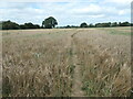
1
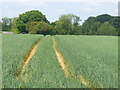
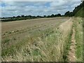
Tramlines at Medstead
Wheel tracks are visible in this cereal field by Medstead village.
Image: © Colin Smith
Taken: 21 May 2011
0.07 miles
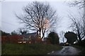
2
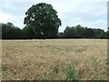
Tree on a former field boundary, Croom's Hill
The boundary no longer exists beyond [north of] the tree.
Image: © Christine Johnstone
Taken: 21 Aug 2023
0.07 miles
3
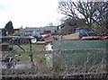
Tractor anyone?
Lots of disused tractors and diggers at the back of this farmyard near Medstead.
Image: © Graham Horn
Taken: 18 Mar 2007
0.12 miles
5
Public footpath near Croom's Hill, Medstead
Heading north-west across a barley field.
Image: © Christine Johnstone
Taken: 21 Aug 2023
0.13 miles
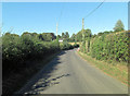
7
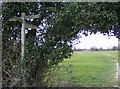
Choice of routes
A choice of five footpath routes here (well four I suppose assuming you don't want to go back the way you came). All are clearly marked on the map, and clearly seen on the ground; a crossroads with an additional leg going north-east.
Image: © Graham Horn
Taken: 18 Mar 2007
0.16 miles
8
Footpath approaching Medstead
Just south from where the path splits (shown on the map), a typical field headland path. Most of the footpath and the building is in this square. The lane to the right leads to Croom's Hill in the next square.
Image: © Graham Horn
Taken: 18 Mar 2007
0.17 miles
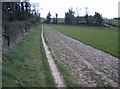
9
Field edge path, Medstead
Heading north-west towards Hattingley.
Image: © Christine Johnstone
Taken: 21 Aug 2023
0.17 miles
10
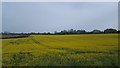
Farmland near to Hattingley
A large field of oil seed rape coming towards harvest.
Image: © Peter Mackenzie
Taken: 23 Apr 2019
0.18 miles