IMAGES TAKEN NEAR TO
Kirtle Drive, ALTON, GU34 5HF
Introduction
This page details the photographs taken nearby to Kirtle Drive, GU34 5HF by members of the Geograph project.
The Geograph project started in 2005 with the aim of publishing, organising and preserving representative images for every square kilometre of Great Britain, Ireland and the Isle of Man.

There are currently over 7.5m images from over14,400 individuals and you can help contribute to the project by visiting https://www.geograph.org.uk
Image Map
Images are licensed for reuse under creativecommons.org/licenses/by-sa/2.0
Notes
- Clicking on the map will re-center to the selected point.
- The higher the marker number, the further away the image location is from the centre of the postcode.
Image Listing (24 Images Found)
Images are licensed for reuse under creativecommons.org/licenses/by-sa/2.0
Image
Details
Distance
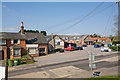
1
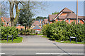
Kirtle Drive
A residential cul de sac seen across the A31 Winchester Road.
Image: © Peter Facey
Taken: 19 Apr 2009
0.02 miles
2
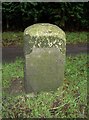
Old Milestone by the A31, Winchester Road, Four Marks parish
Metal plate attached to stone post by the A31, in parish of FOUR MARKS (EAST HAMPSHIRE District), Winchester Road, Greenways Farm, just East of junction with Lapwing Way, between road and footpath, on South side of road. Tasker block, erected by the Winchester & Alton, Lower District turnpike trust in the 19th century.
Inscription reads:-
LONDON
52
WINTON
12
Maker:
TASKER
Milestone Society National ID: HA_WIAL12.
Image: © K Lawrence
Taken: 31 Dec 2002
0.08 miles
3
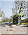
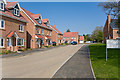
Lapwing Way junction with A31 Winchester Road
Lapwing Way is a new road forming part of the Meadow Brook housing development by Barratt Homes, see http://www.barratthomes.co.uk/ . At time of photographing the Way had not received its final coating of tarmac.
Image: © Peter Facey
Taken: 19 Apr 2009
0.09 miles
4
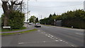
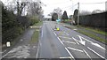
Kingswood Rise, Four Marks
Kingswood Rise joins the busy A31 in Four Marks.
Image: © Peter Mackenzie
Taken: 22 Apr 2019
0.10 miles
5
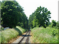
Mid Hants Railway, Four Marks
Looking south-west from the village, whose fringes continue some way on the left of the line, but open fields are on the right.
Image: © Robin Webster
Taken: 9 Jul 2013
0.10 miles
7
Lapwing Way
This is part of the Meadow Brook housing development by Barratt Homes, see http://www.barratthomes.co.uk/ .
(coordinates estimated due to lack of OS mapping)
Image: © Peter Facey
Taken: 19 Apr 2009
0.15 miles
8
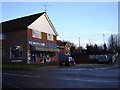
Four Marks Hardware Store
There seems to be a common trend in Hampshire to put hardware stores in small villages. See Image This one has just about everything you need.
Image: © Graham Clutton
Taken: 31 Dec 2005
0.17 miles
9
Mansfield Business Park, Lymington Bottom Road
With Clementines fruit and veg store at left. Viewed from a mound.
Image: © Peter Facey
Taken: 19 Apr 2009
0.17 miles
10
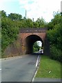
Railway bridge over Lymington Bottom Road
Image: © David Martin
Taken: 10 Jul 2011
0.18 miles