IMAGES TAKEN NEAR TO
Mary Lane, ALTON, GU34 3EN
Introduction
This page details the photographs taken nearby to Mary Lane, GU34 3EN by members of the Geograph project.
The Geograph project started in 2005 with the aim of publishing, organising and preserving representative images for every square kilometre of Great Britain, Ireland and the Isle of Man.

There are currently over 7.5m images from over14,400 individuals and you can help contribute to the project by visiting https://www.geograph.org.uk
Image Map
Images are licensed for reuse under creativecommons.org/licenses/by-sa/2.0
Notes
- Clicking on the map will re-center to the selected point.
- The higher the marker number, the further away the image location is from the centre of the postcode.
Image Listing (6 Images Found)
Images are licensed for reuse under creativecommons.org/licenses/by-sa/2.0
Image
Details
Distance
1
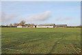
East Tisted, Hampshire
Looking north to Common Barn Farm from the minor road north of Newton Common.
Image: © Brendan and Ruth McCartney
Taken: 3 Feb 2011
0.05 miles
2
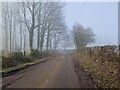
Wandering westwards along the Bashire (21)
Looking westwards along Mary Lane
Image: © Basher Eyre
Taken: 14 Feb 2023
0.15 miles
3
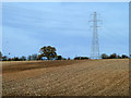
Ploughed field and pylon
North of Mary Lane. According to the map, some old pits should be visible in the field. They seemed to be ploughed out, perhaps where the darker area of soil is.
Image: © Robin Webster
Taken: 13 Nov 2013
0.19 miles
4
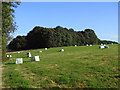
Farmland, Newton Valence
A field with silage bales to the south of Lord's Wood.
Image: © Andrew Smith
Taken: 27 Sep 2009
0.19 miles
5
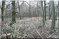
East Tisted, Hampshire
Woodland on the north side of Newton Common viewed from the minor road near Common Barn Farm.
Image: © Brendan and Ruth McCartney
Taken: 3 Feb 2011
0.23 miles
6
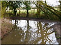
Waterlogged bend on Kitcombe Lane
Kitcombe Lane is a public byway.
Image: © Shazz
Taken: 4 Mar 2014
0.25 miles