IMAGES TAKEN NEAR TO
St. Lawrence Road, ALTON, GU34 2DZ
Introduction
This page details the photographs taken nearby to St. Lawrence Road, GU34 2DZ by members of the Geograph project.
The Geograph project started in 2005 with the aim of publishing, organising and preserving representative images for every square kilometre of Great Britain, Ireland and the Isle of Man.

There are currently over 7.5m images from over14,400 individuals and you can help contribute to the project by visiting https://www.geograph.org.uk
Image Map
Images are licensed for reuse under creativecommons.org/licenses/by-sa/2.0
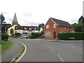
Notes
- Clicking on the map will re-center to the selected point.
- The higher the marker number, the further away the image location is from the centre of the postcode.
Image Listing (347 Images Found)
Images are licensed for reuse under creativecommons.org/licenses/by-sa/2.0
Image
Details
Distance
1
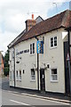
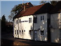
The Eight Bells, Alton
I've not been in this pub for many years, but it was nice on my last visit! My aunt's parents used to run the pub about 60 years ago.
Image: © Peter Trimming
Taken: 14 Jun 2009
0.02 miles
2
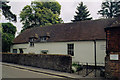
Alton Quaker Meeting House
Erected in 1672.
Image: © Michael FORD
Taken: Unknown
0.03 miles
3
Alton - Quaker Meeting House
At the end of Old Odiham Road, where it becomes Church Street.
Image: © Peter Trimming
Taken: 14 Jun 2009
0.03 miles
4
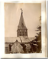
Alton Parish Church hit by lightning 24 June 1880 repaired by brave Steeple Jacks
Steeple Jacks, repairing the steeple of St Lawrence's church, showing off before days of Health and Safety. Taken by a member of the Crowley family who also ran a brewery on the site now occupied by Sainsbury's in Alton.
See Image
Image: © The Crowley family archives
Taken: Unknown
0.04 miles
5
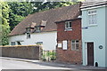
The Eight Bells, Alton
Pub on Church Street, opposite Alton's St Lawrence Church. Perhaps the church has a peal of 8 bells?
Image: © Colin Smith
Taken: 1 Feb 2012
0.04 miles
6
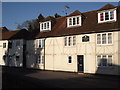
Cromwell House, Alton
Geales Almshouses on Church Street which were founded by a captain in Cromwell's army (1653). They face the parish church which was the scene of a Ciovil War battle (1643).
Image: © Colin Smith
Taken: 1 Feb 2012
0.04 miles
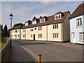
8
Chauntsingers Road, Alton
Chauntsingers Road is a residential road in the town of Alton, in Hampshire.
Image: © Malc McDonald
Taken: 21 Jul 2019
0.04 miles
9
Chauntsingers Road, Alton
Chauntsingers Road in Alton, in Hampshire.
Image: © Malc McDonald
Taken: 21 Jul 2019
0.04 miles
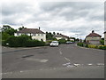
10
Looking east-north-east along Spitalfields Road
Image: © Basher Eyre
Taken: 5 Jan 2013
0.04 miles