IMAGES TAKEN NEAR TO
Envis Way, GUILDFORD, GU3 3NJ
Introduction
This page details the photographs taken nearby to Envis Way, GU3 3NJ by members of the Geograph project.
The Geograph project started in 2005 with the aim of publishing, organising and preserving representative images for every square kilometre of Great Britain, Ireland and the Isle of Man.

There are currently over 7.5m images from over14,400 individuals and you can help contribute to the project by visiting https://www.geograph.org.uk
Image Map
Images are licensed for reuse under creativecommons.org/licenses/by-sa/2.0
Notes
- Clicking on the map will re-center to the selected point.
- The higher the marker number, the further away the image location is from the centre of the postcode.
Image Listing (5 Images Found)
Images are licensed for reuse under creativecommons.org/licenses/by-sa/2.0
Image
Details
Distance
1
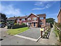
Gumbrells Close - Fairlands
Footpath from Fairlands towards Littlefield Manor.
Image: © James Emmans
Taken: 2 Jun 2020
0.15 miles
2
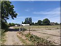
Footpath east of Littlefield Manor
Path from Fairlands.
Image: © James Emmans
Taken: 2 Jun 2020
0.20 miles
3
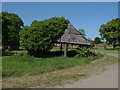
Littlefield Manor
An old outbuilding on the Littlefied estate slowly being pushed over by the weight of the ivy.
Image: © Alan Hunt
Taken: 2 May 2011
0.22 miles
4
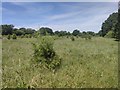
Field close to Hook Farm
Hawthorn is turning field into scrub. The thorn trees look naturally sown as a pioneer species. The farmer maybe starting a rewilding project.
Image: © James Emmans
Taken: 2 Jun 2020
0.23 miles
5
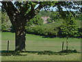
Littlefield Manor
Littlefield Manor from the summit of Anger's Hill.
Image: © Alan Hunt
Taken: 2 May 2011
0.25 miles