IMAGES TAKEN NEAR TO
Hill Brow Road, LISS, GU33 7NF
Introduction
This page details the photographs taken nearby to Hill Brow Road, GU33 7NF by members of the Geograph project.
The Geograph project started in 2005 with the aim of publishing, organising and preserving representative images for every square kilometre of Great Britain, Ireland and the Isle of Man.

There are currently over 7.5m images from over14,400 individuals and you can help contribute to the project by visiting https://www.geograph.org.uk
Image Map
Images are licensed for reuse under creativecommons.org/licenses/by-sa/2.0
Notes
- Clicking on the map will re-center to the selected point.
- The higher the marker number, the further away the image location is from the centre of the postcode.
Image Listing (177 Images Found)
Images are licensed for reuse under creativecommons.org/licenses/by-sa/2.0
Image
Details
Distance
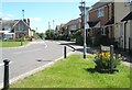
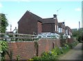
1
Looking down Old School Road towards Collard Way
Image: © Basher Eyre
Taken: 26 Apr 2009
0.03 miles
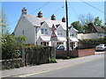
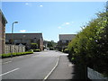
4
View from Summersfield Terrace out onto Hillbrow Road
Image: © Basher Eyre
Taken: 26 Apr 2009
0.04 miles
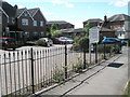
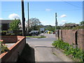
5
View from car park entrance out into Hillbrow Road
Image: © Basher Eyre
Taken: 26 Apr 2009
0.04 miles
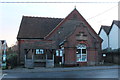
6
Another one off my Liss (153)
The Village Car Park
Image: © Basher Eyre
Taken: 8 Apr 2022
0.04 miles
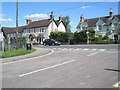
7
Another one off my Liss (152)
Western tip of The Triangle
Image: © Basher Eyre
Taken: 8 Apr 2022
0.05 miles