IMAGES TAKEN NEAR TO
Chase Road, LISS, GU33 7NA
Introduction
This page details the photographs taken nearby to Chase Road, GU33 7NA by members of the Geograph project.
The Geograph project started in 2005 with the aim of publishing, organising and preserving representative images for every square kilometre of Great Britain, Ireland and the Isle of Man.

There are currently over 7.5m images from over14,400 individuals and you can help contribute to the project by visiting https://www.geograph.org.uk
Image Map
Images are licensed for reuse under creativecommons.org/licenses/by-sa/2.0
Notes
- Clicking on the map will re-center to the selected point.
- The higher the marker number, the further away the image location is from the centre of the postcode.
Image Listing (7 Images Found)
Images are licensed for reuse under creativecommons.org/licenses/by-sa/2.0
Image
Details
Distance
1
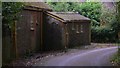
Outbuildings at Little Coppins at the end of Huntsbottom Lane
Image: © Shazz
Taken: 10 Aug 2009
0.06 miles
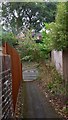
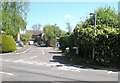
3
Housing estate on the East side of Liss village.
Image: © Martyn Pattison
Taken: 18 May 2005
0.10 miles
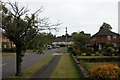
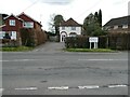
4
Rake Road, East Liss
At the junction with Hatch Lane
Image: © David Howard
Taken: 13 Oct 2018
0.18 miles
5
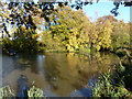
Pond, Liss
At the side of the playing fields.
Image: © Robin Webster
Taken: 23 Nov 2013
0.22 miles
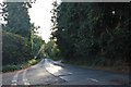
6
Looking from Mill Road into Meadow Field
Image: © Basher Eyre
Taken: 26 Apr 2009
0.25 miles
7
Another one off my Liss (143)
Vets in Mill Road
Image: © Basher Eyre
Taken: 8 Apr 2022
0.25 miles