IMAGES TAKEN NEAR TO
Cole Close, LISS, GU33 7FL
Introduction
This page details the photographs taken nearby to Cole Close, GU33 7FL by members of the Geograph project.
The Geograph project started in 2005 with the aim of publishing, organising and preserving representative images for every square kilometre of Great Britain, Ireland and the Isle of Man.

There are currently over 7.5m images from over14,400 individuals and you can help contribute to the project by visiting https://www.geograph.org.uk
Image Map
Images are licensed for reuse under creativecommons.org/licenses/by-sa/2.0
Notes
- Clicking on the map will re-center to the selected point.
- The higher the marker number, the further away the image location is from the centre of the postcode.
Image Listing (7 Images Found)
Images are licensed for reuse under creativecommons.org/licenses/by-sa/2.0
Image
Details
Distance
2
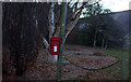
Post box at Prince's Marsh
This is outside Andlers Ash farm.
Image: © Robert Eva
Taken: 14 Jan 2017
0.15 miles
5
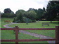
Seated area at Newman Collard
A place for young and old alike to relax.
Image: © Basher Eyre
Taken: 13 Aug 2007
0.25 miles
6
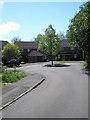
Small traffic island at the end of Longmead
Image: © Basher Eyre
Taken: 26 Apr 2009
0.25 miles
7
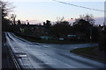
Andlers Ash Road, Liss
The Shipwrights Way goes down this road.
Image: © Robert Eva
Taken: 14 Jan 2017
0.25 miles