IMAGES TAKEN NEAR TO
Farnham Road, LISS, GU33 6LJ
Introduction
This page details the photographs taken nearby to Farnham Road, GU33 6LJ by members of the Geograph project.
The Geograph project started in 2005 with the aim of publishing, organising and preserving representative images for every square kilometre of Great Britain, Ireland and the Isle of Man.

There are currently over 7.5m images from over14,400 individuals and you can help contribute to the project by visiting https://www.geograph.org.uk
Image Map
Images are licensed for reuse under creativecommons.org/licenses/by-sa/2.0
Notes
- Clicking on the map will re-center to the selected point.
- The higher the marker number, the further away the image location is from the centre of the postcode.
Image Listing (9 Images Found)
Images are licensed for reuse under creativecommons.org/licenses/by-sa/2.0
Image
Details
Distance
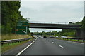
4
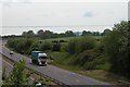
A3 Petersfield bypass and farmland.
Taken from the Flexcombe interchange bridge.
Image: © Martyn Pattison
Taken: 18 May 2005
0.18 miles
8
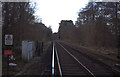
Railway line towards Petersfield
Taken from the Andlers Ash Road level crossing
Image: © Robert Eva
Taken: 14 Jan 2017
0.20 miles