IMAGES TAKEN NEAR TO
LISS, GU33 6LD
Introduction
This page details the photographs taken nearby to GU33 6LD by members of the Geograph project.
The Geograph project started in 2005 with the aim of publishing, organising and preserving representative images for every square kilometre of Great Britain, Ireland and the Isle of Man.

There are currently over 7.5m images from over14,400 individuals and you can help contribute to the project by visiting https://www.geograph.org.uk
Image Map
Images are licensed for reuse under creativecommons.org/licenses/by-sa/2.0
Notes
- Clicking on the map will re-center to the selected point.
- The higher the marker number, the further away the image location is from the centre of the postcode.
Image Listing (27 Images Found)
Images are licensed for reuse under creativecommons.org/licenses/by-sa/2.0
Image
Details
Distance
1
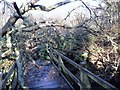
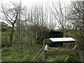
Liss Riverside Railway Walk
Fallen tree on Shepherd Bridge - December 2013
Image: © John Neilan
Taken: 26 Dec 2013
0.12 miles
2
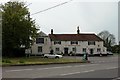
The Spread Eagle, West Liss
The area in front of the pub, was known as the Plestor and was the location for the stocks. The Oak tree dates from this period.
Image: © Martyn Pattison
Taken: 18 May 2005
0.12 miles
3
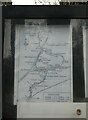
Another one off my Liss (36)
The route outlined on a notice board just off the path following the former Longmoor Military Railway, now a designated local walk https://en.wikipedia.org/wiki/Liss_Riverside_Railway_Walk_North
For a history of the railway, see https://www.irsociety.co.uk/Archives/9/longmoor.htm
Image: © Basher Eyre
Taken: 8 Apr 2022
0.16 miles
4
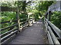
Shipwrights' Way 81
Now the path uses Nightingale Bridge. See also http://www.geograph.org.uk/photo/3754306.
Image: © Shazz
Taken: 21 Aug 2016
0.17 miles
5
Another one off my Liss (35)
Bird identification chart as seen on the route of the former Longmoor Military Railway, now a designated local walk https://en.wikipedia.org/wiki/Liss_Riverside_Railway_Walk_North
Image: © Basher Eyre
Taken: 8 Apr 2022
0.17 miles
6
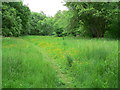
Footpath through meadow on Liss Riverside Railway Walk
Image: © John Neilan
Taken: 9 Jun 2013
0.17 miles
7
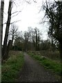
Another one off my Liss (37)
Mid section of the path from Liss village centre to Liss Forest- it follows the trackbed of the old Longmoor Military Railway https://en.wikipedia.org/wiki/Longmoor_Military_Railway
Image: © Basher Eyre
Taken: 8 Apr 2022
0.17 miles
8
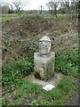
Another one off my Liss (34)
Sculpture on the path following the route of the former Longmoor Military Railway, which is also on The Shipwright's Way
https://documents.hants.gov.uk/countryside/walks/ShipwrightsWay-sculptures.pdf
For a history of the railway, see https://www.irsociety.co.uk/Archives/9/longmoor.htm
Image: © Basher Eyre
Taken: 8 Apr 2022
0.18 miles
9
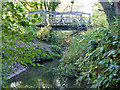
Nightingale Bridge, former Longmoor Military Railway
Now used as a public footpath.
Image: © Robin Webster
Taken: 23 Nov 2013
0.18 miles
10
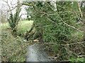
Another one off my Liss (33)
Stream seen from Rotherbank Farm Bridge on the path following the route of the former Longmoor Military Railway, now a designated local walk https://en.wikipedia.org/wiki/Liss_Riverside_Railway_Walk_North
For a history of the railway, see https://www.irsociety.co.uk/Archives/9/longmoor.htm
Image: © Basher Eyre
Taken: 8 Apr 2022
0.18 miles