IMAGES TAKEN NEAR TO
Farnham Road, LISS, GU33 6JG
Introduction
This page details the photographs taken nearby to Farnham Road, GU33 6JG by members of the Geograph project.
The Geograph project started in 2005 with the aim of publishing, organising and preserving representative images for every square kilometre of Great Britain, Ireland and the Isle of Man.

There are currently over 7.5m images from over14,400 individuals and you can help contribute to the project by visiting https://www.geograph.org.uk
Image Map
Images are licensed for reuse under creativecommons.org/licenses/by-sa/2.0
Notes
- Clicking on the map will re-center to the selected point.
- The higher the marker number, the further away the image location is from the centre of the postcode.
Image Listing (87 Images Found)
Images are licensed for reuse under creativecommons.org/licenses/by-sa/2.0
Image
Details
Distance
1
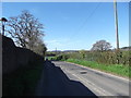
Farnham Road, Liss
This used to be the A325, the main road from Farnham to Petersfield until the A3 bypass was opened in 1992.
Image: © easthantsxc
Taken: 2 May 2013
0.02 miles
3
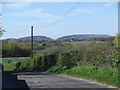
Farnham Road, Liss
Again, on the old A325 - good views of Butser in the South.
Image: © easthantsxc
Taken: 2 May 2013
0.11 miles
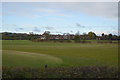
4

Bishearne Gardens
Taken from Station Road.
Image: © Basher Eyre
Taken: 26 Apr 2009
0.12 miles
6

Junction of Bishearne Gardens and Station Road
Image: © Basher Eyre
Taken: 26 Apr 2009
0.13 miles
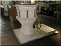
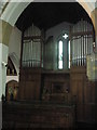
7
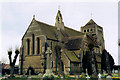
St Mary, Liss
Grade 2 listed building erected in 1891.
Image: © Michael FORD
Taken: Unknown
0.13 miles
9

Saint Mary, Liss: CWGC grave (XI)
Also see http://www.cwgc.org/find-war-dead/casualty/2438926/DOWELL,%20CLIFFORD%20STANHOPE
Image: © Basher Eyre
Taken: 15 Jun 2016
0.13 miles
10
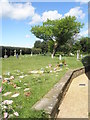
Tree in the churchyard at St Mary's, Liss
Image: © Basher Eyre
Taken: 26 Apr 2009
0.13 miles