IMAGES TAKEN NEAR TO
Selborne Road, LISS, GU33 6HG
Introduction
This page details the photographs taken nearby to Selborne Road, GU33 6HG by members of the Geograph project.
The Geograph project started in 2005 with the aim of publishing, organising and preserving representative images for every square kilometre of Great Britain, Ireland and the Isle of Man.

There are currently over 7.5m images from over14,400 individuals and you can help contribute to the project by visiting https://www.geograph.org.uk
Image Map
Images are licensed for reuse under creativecommons.org/licenses/by-sa/2.0
Notes
- Clicking on the map will re-center to the selected point.
- The higher the marker number, the further away the image location is from the centre of the postcode.
Image Listing (123 Images Found)
Images are licensed for reuse under creativecommons.org/licenses/by-sa/2.0
Image
Details
Distance
1
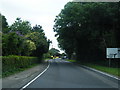
Petersfield Road nears Toll House Corner
Image: © Colin Pyle
Taken: 12 Aug 2012
0.04 miles
2
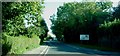
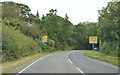
Approaching road junction at Greatham village
On the B3006
Image: © Clint Mann
Taken: 2 Oct 2015
0.04 miles
3
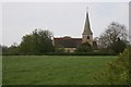
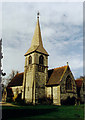
Greatham
The Parish Church of St John the Baptist.
Image: © Brendan and Ruth McCartney
Taken: 22 Apr 2005
0.15 miles
6
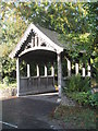
The lych gate at St John the Baptist, Greatham
Image: © Basher Eyre
Taken: 10 Oct 2009
0.16 miles
7
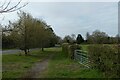
Looking south-southwest along Petersfield Road
Image: © Basher Eyre
Taken: 8 Apr 2021
0.16 miles
8
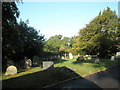
Shadows in the churchyard at St John the Baptist, Greatham
Image: © Basher Eyre
Taken: 10 Oct 2009
0.16 miles
9
St John the Baptist, Greatham
Grade 2 listed building erected in 1875.
Image: © Michael FORD
Taken: Unknown
0.17 miles
10
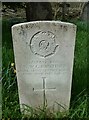
CWGC grave in Greatham New Churchyard (4)
Boy Benjamin William George Bunting, Army Service Corps
Image: © Basher Eyre
Taken: 8 Apr 2021
0.17 miles