IMAGES TAKEN NEAR TO
Blackmoor Road, LISS, GU33 6BJ
Introduction
This page details the photographs taken nearby to Blackmoor Road, GU33 6BJ by members of the Geograph project.
The Geograph project started in 2005 with the aim of publishing, organising and preserving representative images for every square kilometre of Great Britain, Ireland and the Isle of Man.

There are currently over 7.5m images from over14,400 individuals and you can help contribute to the project by visiting https://www.geograph.org.uk
Image Map
Images are licensed for reuse under creativecommons.org/licenses/by-sa/2.0
Notes
- Clicking on the map will re-center to the selected point.
- The higher the marker number, the further away the image location is from the centre of the postcode.
Image Listing (8 Images Found)
Images are licensed for reuse under creativecommons.org/licenses/by-sa/2.0
Image
Details
Distance
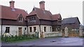
1
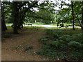
Former gate for drive to Blackmoor House
Now only the entrance to the grounds of an enlarged South Lodge here. The rest of the drive has been ploughed out in fields. Access to Blackmoor House is now only via the northern drive.
Image: © Robin Webster
Taken: 16 Nov 2013
0.01 miles
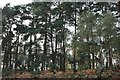
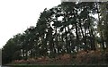
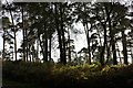
3
Shipwrights' Way 63
The A325 is seen through the trees at its junction with Blackmoor Road.
Image: © Shazz
Taken: 21 Aug 2016
0.11 miles
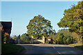
4
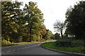
Blackmoor Road at the junction of Petersfield Road
Image: © David Howard
Taken: 13 Oct 2018
0.11 miles
6
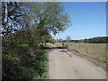
Top end of Benhams Lane
Nice little cyclable track. Cuts out a bit of the A325.
Image: © easthantsxc
Taken: 13 Apr 2014
0.19 miles