IMAGES TAKEN NEAR TO
Benhams Lane, LISS, GU33 6BA
Introduction
This page details the photographs taken nearby to Benhams Lane, GU33 6BA by members of the Geograph project.
The Geograph project started in 2005 with the aim of publishing, organising and preserving representative images for every square kilometre of Great Britain, Ireland and the Isle of Man.

There are currently over 7.5m images from over14,400 individuals and you can help contribute to the project by visiting https://www.geograph.org.uk
Image Map
Images are licensed for reuse under creativecommons.org/licenses/by-sa/2.0
Notes
- Clicking on the map will re-center to the selected point.
- The higher the marker number, the further away the image location is from the centre of the postcode.
Image Listing (12 Images Found)
Images are licensed for reuse under creativecommons.org/licenses/by-sa/2.0
Image
Details
Distance
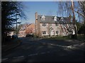
1
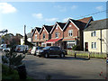
Woolmer Villas, built 1903
The one with the blind is mapped as a post office, but there is no sign of that now. It 'only' claims to be Shop - Cafe- Takeaway - Off Licence.
Image: © Robin Webster
Taken: 16 Nov 2013
0.05 miles
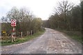
2
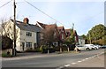
Benham's Lane, Greatham
The row of barriers along the entire length of this road make it into the most dangerous road I am ever aware of driving along. They are on alternate sides and if there are more than a couple of cars on the road at least one gets confused and you have to make more effort to avoid them than negotiate the mess.
Image: © David Howard
Taken: 13 Oct 2018
0.08 miles
3
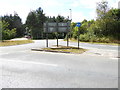
Shipwrights' Way 65
The Way crosses the roundabout and leaves by Digby Way.
Image: © Shazz
Taken: 21 Aug 2016
0.08 miles
4
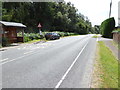
Shipwrights' Way 66
The Way continues on Petersfield Road through Greatham, passing a bus stop.
Image: © Shazz
Taken: 21 Aug 2016
0.10 miles
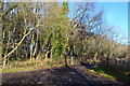
5
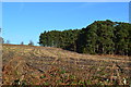
View across stubble field from Benhams Lane
Image: © David Martin
Taken: 2 Dec 2012
0.10 miles
6
Shipwrights' Way 64
The path continues by the A325 and a road sign indicates the imminence of the roundabout at Greatham.
Image: © Shazz
Taken: 21 Aug 2016
0.11 miles
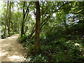
8
Former Longmoor Military Railway, looking south
The trackbed of the former Longmoor Military Railway, looking south. The railway was principally used to train soldiers in the operation of railways, and linked Liss with Bordon Camp, with a loop track around the Woolmer Forest area.
Image: © Chris Wood
Taken: 9 Apr 2007
0.19 miles
9
Silver Birch Mews, Greatham
On the site of the Silver Birch pub (closed 2002), formerly the Woolmer Hotel, on the site of the earlier Bricklayer's Arms.
Image: © David960
Taken: 16 Feb 2014
0.20 miles
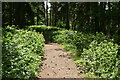
10
Lane towards Keepers Cottage, from Benhams Lane
Image: © David Martin
Taken: 2 Dec 2012
0.21 miles