IMAGES TAKEN NEAR TO
Elm Hill, GUILDFORD, GU3 2HZ
Introduction
This page details the photographs taken nearby to Elm Hill, GU3 2HZ by members of the Geograph project.
The Geograph project started in 2005 with the aim of publishing, organising and preserving representative images for every square kilometre of Great Britain, Ireland and the Isle of Man.

There are currently over 7.5m images from over14,400 individuals and you can help contribute to the project by visiting https://www.geograph.org.uk
Image Map
Images are licensed for reuse under creativecommons.org/licenses/by-sa/2.0
Notes
- Clicking on the map will re-center to the selected point.
- The higher the marker number, the further away the image location is from the centre of the postcode.
Image Listing (11 Images Found)
Images are licensed for reuse under creativecommons.org/licenses/by-sa/2.0
Image
Details
Distance

2

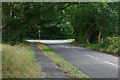
Junction of A323 and A324, Wyke
Looking from the A323, which continues towards Ash and Aldershot.
Image: © Robin Webster
Taken: 2 Aug 2020
0.05 miles
3

Lights at the junction of the A323 and A324
Turn left for Woking, straight ahead for Guildford
Image: © David Howard
Taken: 30 Jun 2013
0.08 miles

7

Pre-Worboys route confirmation, A324 Wyke
Image: © David Howard
Taken: 15 Feb 2009
0.14 miles
8
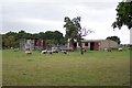
Normandy sheep farm
Sheep are not widely kept in Surrey but near the junction of the A324 and A323 roads at Normandy are a few fields in which they are kept on a small scale. The idea of grazing sheep on open access heathland to help maintain the habitat is being actively considered by Surrey County Council, with advice from projects in the Netherlands and on Germany's Luneberg Heath.
Image: © Ron Strutt
Taken: 27 Sep 2005
0.16 miles
9

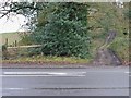
Follyhatch Lane
The footpath known as Follyhatch lane with one of the houses at the bottom of Wyke Avenue
Image: © Alan Hunt
Taken: 30 Jul 2011
0.17 miles
10
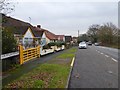
Wyke Lane, Normandy
Looking towards the junction of Wyke Lane with the A323, Guildford Road.
Image: © Alan Hunt
Taken: 13 Aug 2016
0.24 miles