IMAGES TAKEN NEAR TO
Church Road, PETERSFIELD, GU32 2DN
Introduction
This page details the photographs taken nearby to Church Road, GU32 2DN by members of the Geograph project.
The Geograph project started in 2005 with the aim of publishing, organising and preserving representative images for every square kilometre of Great Britain, Ireland and the Isle of Man.

There are currently over 7.5m images from over14,400 individuals and you can help contribute to the project by visiting https://www.geograph.org.uk
Image Map (Loading...)


Getting Data...Please wait
Leaflet Map data © OpenStreetMap
Images are licensed for reuse under creativecommons.org/licenses/by-sa/2.0
Notes
- Clicking on the map will re-center to the selected point.
- The higher the marker number, the further away the image location is from the centre of the postcode.
Image Listing (11 Images Found)
Images are licensed for reuse under creativecommons.org/licenses/by-sa/2.0
Image
Details
Distance
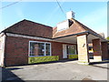
1
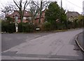
The junction of Mill Lane with Church Road in Steep
The Roll of Honour memorial is at the junction, see http://www.geograph.org.uk/photo/2215429.
Image: © Shazz
Taken: 31 Dec 2010
0.06 miles
3
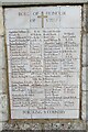
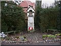
Detail on Steep War Memorial
As often my Geograph buddy Shazz had been before me https://www.geograph.org.uk/photo/2215429 I was looking for Edward Thomas, who lived locally. The two World Wars were major historical events. This month we have seen: the former Japanese Prime Minister Shinzo Abe assassinated (8th); the storming of the Sri Lankan President's Official Residence 99th); the hottest ever temperatures in the UK (19th); and race to be the next Tory Prime Minister reduced to two candidates (20th) https://www.theguardian.com/politics/live/2022/jul/20/tory-leadership-race-live-sunak-mordaunt-truss-latest-uk-politics
Image: © Basher Eyre
Taken: 31 Jul 2022
0.07 miles
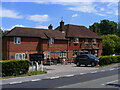
4
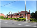
Petersfield Means Business (174)
The Cricketers, Steep
Image: © Basher Eyre
Taken: 27 Oct 2019
0.14 miles
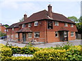
5
The Cricketers, Steep - Survived the lockdown
Happily the Cricketers survived the lockdown, in part due to offering a takeaway service, and is open for business as usual.
Image
Image: © Martyn Pattison
Taken: 10 Jul 2022
0.14 miles
6
The Cricketers, Steep - closed for the duration
The Cricketers has now been closed for almost two months as a result of the Coronavirus lockdown.
Image
Image: © Martyn Pattison
Taken: 17 May 2020
0.14 miles
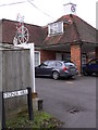
7

Old Direction Sign - Signpost by Stoner Hill, Steep
Annulus finial - 4 arms; Hampshire Parish halo by the UC road, in parish of Steep (East Hampshire District), Steep, junction of Church Road with Stoner Hill, Northeast corner of crossroads, in hedge by Cricketers Inn.
To be surveyed
Milestone Society National ID: HA_SU7325
Image: © Milestone Society
Taken: Unknown
0.14 miles
8
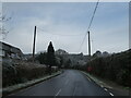
Looking from The Cricketers up the road to Stoner Hill
Image: © Basher Eyre
Taken: 11 Dec 2022
0.16 miles
9
Very wrong clock on Stoner Hill
The time was actually ten past two. The penny farthing is advertising a cycle shop.
Image: © Shazz
Taken: 31 Dec 2010
0.18 miles
10
Petersfield Means Business (173)
Owen Cycles, Stoner Hill with Evoke Kitchens beyond
Image: © Basher Eyre
Taken: 27 Oct 2019
0.18 miles