IMAGES TAKEN NEAR TO
Harvesting Lane, PETERSFIELD, GU32 1QR
Introduction
This page details the photographs taken nearby to Harvesting Lane, GU32 1QR by members of the Geograph project.
The Geograph project started in 2005 with the aim of publishing, organising and preserving representative images for every square kilometre of Great Britain, Ireland and the Isle of Man.

There are currently over 7.5m images from over14,400 individuals and you can help contribute to the project by visiting https://www.geograph.org.uk
Image Map
Images are licensed for reuse under creativecommons.org/licenses/by-sa/2.0
Notes
- Clicking on the map will re-center to the selected point.
- The higher the marker number, the further away the image location is from the centre of the postcode.
Image Listing (6 Images Found)
Images are licensed for reuse under creativecommons.org/licenses/by-sa/2.0
Image
Details
Distance
1
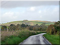
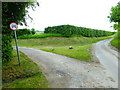
Harvesting Lane
Park Hill is prominent in the distance.
Image: © Robin Webster
Taken: 2 Nov 2013
0.11 miles
2
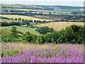
Looking down on Upper Parsonage Farm from Butser
Upper Parsonage Farm lies along Harvesting Lane to the west of Butser Hill and about 120m (400') lower in elevation. Behind it the rolling farmland leads onto the hills that curve around the western side of the village of East Meon.
See also Image], Image] and Image] for similar views.
See also the shared descriptions below:
Image: © Rob Farrow
Taken: 18 Jul 2015
0.12 miles
3
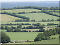
Preston Farm from Wether Down
Downland landscape, a patchwork of green fields lined by hedgerows, adjacent to the source of the River Meon.
Image: © Colin Smith
Taken: 19 Jun 2012
0.19 miles
4
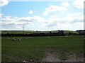
Sheep Farming at the foot of the South Downs
Image: © Martyn Pattison
Taken: 11 Apr 2005
0.19 miles
6
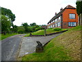
Fishpond Cottage
See also http://www.geograph.org.uk/photo/2640.
Image: © Shazz
Taken: 31 May 2014
0.25 miles