IMAGES TAKEN NEAR TO
Station Road, PETERSFIELD, GU32 1JQ
Introduction
This page details the photographs taken nearby to Station Road, GU32 1JQ by members of the Geograph project.
The Geograph project started in 2005 with the aim of publishing, organising and preserving representative images for every square kilometre of Great Britain, Ireland and the Isle of Man.

There are currently over 7.5m images from over14,400 individuals and you can help contribute to the project by visiting https://www.geograph.org.uk
Image Map
Images are licensed for reuse under creativecommons.org/licenses/by-sa/2.0
Notes
- Clicking on the map will re-center to the selected point.
- The higher the marker number, the further away the image location is from the centre of the postcode.
Image Listing (68 Images Found)
Images are licensed for reuse under creativecommons.org/licenses/by-sa/2.0
Image
Details
Distance
1
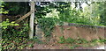
Bridge Parapet with Cut Benchmark
Here, Station Road crosses the West Meon Trail, formerly a railway.
Image: © Paul Collins
Taken: 5 Sep 2021
0.03 miles
2

Underside of Bridge, West Meon Trail
Here, Station Road crosses the West Meon Trail, formerly the village railway station.
Image: © Paul Collins
Taken: 5 Sep 2021
0.03 miles
3
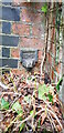
Projecting Bracket Bench Mark on Bridge at Former Station
A projecting bracket is a rare type of bench mark and a predecessor of the more common 'Flush Bracket'. Bench marks were semi-permanent markers installed by the Ordnance Survey as part of the levelling of Great Britain. This bracket is found on the bridge abutment which carries Station Road over the former West Meon Railway Station platform. This bracket was installed in 1912 and levelled with a height of 321.6620 feet above mean sea level.
Image: © Paul Collins
Taken: 5 Sep 2021
0.03 miles
4
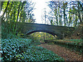
Bridge and platforms, West Meon station
The Meon Valley line station closed in 1955. The platforms are of some length, and extend under the bridge which seems to be built to accommodate them.
Image: © Robin Webster
Taken: 6 Dec 2013
0.03 miles
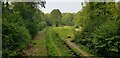
5
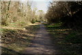
Meon Valley Trail
Looking along the northern end of the trail towards the car park at the site of West Meon Station.
Image: © Pierre Terre
Taken: 27 Mar 2008
0.04 miles
6
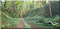
West Meon Trail
This image is captured from the platform of the long-disused West Meon Railway Station.
Image: © Paul Collins
Taken: 5 Sep 2021
0.05 miles
7
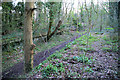
Remains of West Meon Station
Overgrown platforms at the north end of the Meon Valley Trail
Image: © Pierre Terre
Taken: 27 Mar 2008
0.06 miles
8
Car Park at West Meon Trail
The car park is on the site of the former goods yard of West Meon Railway Station. The main station building stood on the left, where the fence is.
Image: © Paul Collins
Taken: 5 Sep 2021
0.07 miles
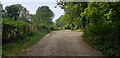
9
Access Road to West Meon Trail
This drive serves the carpark and picnic area of the West Meon Trail. It was built to serve the West Meon railway station and goods yard, now long gone.
Image: © Paul Collins
Taken: 5 Sep 2021
0.07 miles
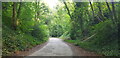
10
West Meon Trail and Picnic Area
The disused railway station platforms are clearly visible. The picnic area and adjacent car park occupy the former goods yards.
Image: © Paul Collins
Taken: 5 Sep 2021
0.08 miles