IMAGES TAKEN NEAR TO
Froxfield, PETERSFIELD, GU32 1DG
Introduction
This page details the photographs taken nearby to GU32 1DG by members of the Geograph project.
The Geograph project started in 2005 with the aim of publishing, organising and preserving representative images for every square kilometre of Great Britain, Ireland and the Isle of Man.

There are currently over 7.5m images from over14,400 individuals and you can help contribute to the project by visiting https://www.geograph.org.uk
Image Map (Loading...)


Getting Data...Please wait
Leaflet Map data © OpenStreetMap
Images are licensed for reuse under creativecommons.org/licenses/by-sa/2.0
Notes
- Clicking on the map will re-center to the selected point.
- The higher the marker number, the further away the image location is from the centre of the postcode.
Image Listing (3 Images Found)
Images are licensed for reuse under creativecommons.org/licenses/by-sa/2.0
Image
Details
Distance
1
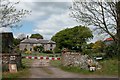
Bydean Farm
The Sarsen stone behind the planter to the right of the entrance is one of several close to the farm.
Image: © Martyn Pattison
Taken: 17 May 2005
0.12 miles
2
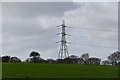
View across field from the corner of Rapley's Copse
The houses are on High Cross Lane. To the right of the pylon the spire of the church at Privett pierces the skyline. It is nearly two miles from the camera.
Image: © Shazz
Taken: 1 Mar 2014
0.13 miles