IMAGES TAKEN NEAR TO
Froxfield, PETERSFIELD, GU32 1BD
Introduction
This page details the photographs taken nearby to GU32 1BD by members of the Geograph project.
The Geograph project started in 2005 with the aim of publishing, organising and preserving representative images for every square kilometre of Great Britain, Ireland and the Isle of Man.

There are currently over 7.5m images from over14,400 individuals and you can help contribute to the project by visiting https://www.geograph.org.uk
Image Map
Images are licensed for reuse under creativecommons.org/licenses/by-sa/2.0
Notes
- Clicking on the map will re-center to the selected point.
- The higher the marker number, the further away the image location is from the centre of the postcode.
Image Listing (22 Images Found)
Images are licensed for reuse under creativecommons.org/licenses/by-sa/2.0
Image
Details
Distance
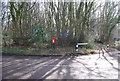
7
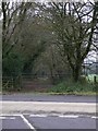
Bridleway continues south west from Honeycritch Lane
Image: © Shazz
Taken: 31 Dec 2010
0.06 miles
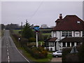
8
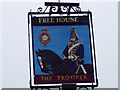
Sign for the Trooper Inn
The term was first used about 1640 for a soldier who was part of a group of cavalry. Latin 'troppus', from which 'troop' means of flock.
Image: © Maigheach-gheal
Taken: 19 Feb 2007
0.06 miles
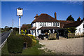
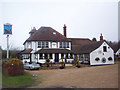
9
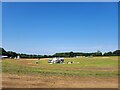
After the Lawn Mowers Show
Yesterday the British Lawn Mower Racing Association held its annual 'Le Man' style marathon grand prix
Image: © Basher Eyre
Taken: 12 Aug 2024
0.08 miles
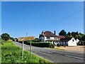
10
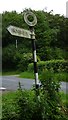
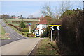
Old Direction Sign - Signpost in Froxfield parish
Annulus finial - 1 arm; Hampshire Parish halo by the UC road, in parish of Froxfield (East Hampshire District), Homefield Farm, fork in road.
Surveyed
Milestone Society National ID: HA_SU7226B
Image: © Milestone Society
Taken: Unknown
0.12 miles