IMAGES TAKEN NEAR TO
Ridge Common Lane, PETERSFIELD, GU32 1AY
Introduction
This page details the photographs taken nearby to Ridge Common Lane, GU32 1AY by members of the Geograph project.
The Geograph project started in 2005 with the aim of publishing, organising and preserving representative images for every square kilometre of Great Britain, Ireland and the Isle of Man.

There are currently over 7.5m images from over14,400 individuals and you can help contribute to the project by visiting https://www.geograph.org.uk
Image Map
Images are licensed for reuse under creativecommons.org/licenses/by-sa/2.0
Notes
- Clicking on the map will re-center to the selected point.
- The higher the marker number, the further away the image location is from the centre of the postcode.
Image Listing (27 Images Found)
Images are licensed for reuse under creativecommons.org/licenses/by-sa/2.0
Image
Details
Distance
1
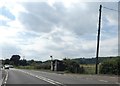
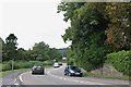
Bus shelter for eastbound buses, A272 in Stroud
Image: © David Smith
Taken: 9 Jul 2019
0.08 miles
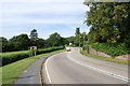
3
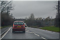
East Hampshire : Winchester Road A272
Heading along Winchester Road and through East Hampshire.
Image: © Lewis Clarke
Taken: 29 Mar 2018
0.12 miles
8
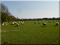
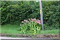
Pregnant ewes near Stroud Common
The fields around here are currently stocked with pregnant Ewes waiting to lamb.
Image: © Martyn Pattison
Taken: 10 Apr 2020
0.16 miles