IMAGES TAKEN NEAR TO
The Guildway, Old Portsmouth Road, GUILDFORD, GU3 1LR
Introduction
This page details the photographs taken nearby to The Guildway, Old Portsmouth Road, GU3 1LR by members of the Geograph project.
The Geograph project started in 2005 with the aim of publishing, organising and preserving representative images for every square kilometre of Great Britain, Ireland and the Isle of Man.

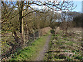
There are currently over 7.5m images from over14,400 individuals and you can help contribute to the project by visiting https://www.geograph.org.uk
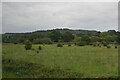
Image Map
Images are licensed for reuse under creativecommons.org/licenses/by-sa/2.0
Notes
- Clicking on the map will re-center to the selected point.
- The higher the marker number, the further away the image location is from the centre of the postcode.
Image Listing (78 Images Found)
Images are licensed for reuse under creativecommons.org/licenses/by-sa/2.0
Image
Details
Distance
1
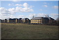
Portsmouth Direct Line and adjacent buildings
Image: © N Chadwick
Taken: 2 Feb 2013
0.03 miles
2
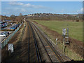
Approaching Guildford
The main line passing through Artington on its way to Guildford. In the background is the upmarket area around Pewley Point and Pewley Down. St Mary's church spire is on the right. On the left are the car parks for the Artington business park.
Image: © Alan Hunt
Taken: 26 Feb 2014
0.04 miles
4
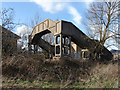
Railway footbridge
The footbridge over the rail lines at the back of Artington business park.
Image: © Alan Hunt
Taken: 26 Feb 2014
0.05 miles
5
Footpath, Artington
The path between the railway line and the River Wey Navigation.
Image: © Alan Hunt
Taken: 26 Feb 2014
0.08 miles
6
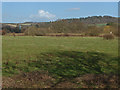
View towards the Chantries
Looking northeast from the footpath between Artington and the river Wey with the spire of St Mary's on the left and the woods on top of Chantries in the background. The bank at the far end of the field marks the course of the Guildford to Dorking railway line.
Image: © Alan Hunt
Taken: 26 Feb 2014
0.09 miles
8
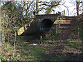
Disused railway bridge
The old bridge on the link line between the Dorking and Portsmouth lines south of Guildford. The embankment was built in the 1850s as a speculative venture but it appears that the tracks were never laid.
Image: © Alan Hunt
Taken: 26 Feb 2014
0.13 miles
9
Land between the Portsmouth Direct Line and The North Downs Line
Image: © N Chadwick
Taken: 30 May 2019
0.13 miles
10
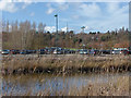
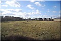
Artington park and ride
Looking west across the park and ride from the footpath along the railway line. The mast on the horizon belongs to the Surrey Police headquarters at Mount Browne.
Image: © Alan Hunt
Taken: 26 Feb 2014
0.14 miles