IMAGES TAKEN NEAR TO
Ditcham, PETERSFIELD, GU31 5RL
Introduction
This page details the photographs taken nearby to GU31 5RL by members of the Geograph project.
The Geograph project started in 2005 with the aim of publishing, organising and preserving representative images for every square kilometre of Great Britain, Ireland and the Isle of Man.

There are currently over 7.5m images from over14,400 individuals and you can help contribute to the project by visiting https://www.geograph.org.uk
Image Map (Loading...)


Getting Data...Please wait
Leaflet Map data © OpenStreetMap
Images are licensed for reuse under creativecommons.org/licenses/by-sa/2.0
Notes
- Clicking on the map will re-center to the selected point.
- The higher the marker number, the further away the image location is from the centre of the postcode.
Image Listing (5 Images Found)
Images are licensed for reuse under creativecommons.org/licenses/by-sa/2.0
Image
Details
Distance
1
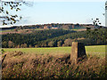
View from the trig point
Looking towards Ditcham Park School. The pillar has flush bracket number S4043 and is mapped at 143 m. There is a small island of vegetation with trees here, with a low mound, but it has never been mapped as a tumulus.
Image: © Robin Webster
Taken: 4 Nov 2013
0.17 miles
3
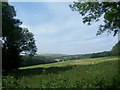
Field at Ditcham Park, towards Woodcroft Farm
with views over to south side of South Downs in distance
Image: © Keith Rose
Taken: 11 Jun 2006
0.23 miles