IMAGES TAKEN NEAR TO
Rogate, PETERSFIELD, GU31 5EQ
Introduction
This page details the photographs taken nearby to GU31 5EQ by members of the Geograph project.
The Geograph project started in 2005 with the aim of publishing, organising and preserving representative images for every square kilometre of Great Britain, Ireland and the Isle of Man.

There are currently over 7.5m images from over14,400 individuals and you can help contribute to the project by visiting https://www.geograph.org.uk
Image Map
Images are licensed for reuse under creativecommons.org/licenses/by-sa/2.0
Notes
- Clicking on the map will re-center to the selected point.
- The higher the marker number, the further away the image location is from the centre of the postcode.
Image Listing (8 Images Found)
Images are licensed for reuse under creativecommons.org/licenses/by-sa/2.0
Image
Details
Distance
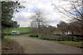
1
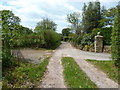
Restricted Byway passing Mill's Farm House
Image: © Dave Spicer
Taken: 13 May 2012
0.02 miles
2
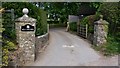
Entrance to Mills Farm House on Cumber's Lane
There is an apostrophe on the map but not on this sign.
Image: © Shazz
Taken: 6 May 2009
0.03 miles
3
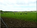
Cattle in field north of Mill's Farm House
Image: © Dave Spicer
Taken: 13 May 2012
0.10 miles
4
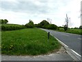
A272 west to Rogate and onto Petersfield
Image: © Dave Spicer
Taken: 13 May 2012
0.11 miles
5
Old Alignment of A272
The end of the old route of the A272, retained for access to Terwick church and one or two houses. The horsebox is passing on the new alignment.
Image: © Robin Webster
Taken: 26 Feb 2007
0.12 miles
6
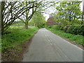
Former A272 to Rogate
Now just a service road to Terwick Church and Old Rectory.
Image: © Dave Spicer
Taken: 13 May 2012
0.16 miles
7
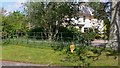
Large house near Terwick church
I do not know the name of this house but it is next to "The Old Rectory". The road was once part of the A272 before it was straightened and is now a quiet cul de sac.
Image: © Shazz
Taken: 6 May 2009
0.20 miles
