IMAGES TAKEN NEAR TO
West Harting Road, PETERSFIELD, GU31 5BG
Introduction
This page details the photographs taken nearby to West Harting Road, GU31 5BG by members of the Geograph project.
The Geograph project started in 2005 with the aim of publishing, organising and preserving representative images for every square kilometre of Great Britain, Ireland and the Isle of Man.

There are currently over 7.5m images from over14,400 individuals and you can help contribute to the project by visiting https://www.geograph.org.uk
Image Map
Images are licensed for reuse under creativecommons.org/licenses/by-sa/2.0
Notes
- Clicking on the map will re-center to the selected point.
- The higher the marker number, the further away the image location is from the centre of the postcode.
Image Listing (10 Images Found)
Images are licensed for reuse under creativecommons.org/licenses/by-sa/2.0
Image
Details
Distance
1
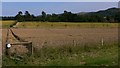
Footpath through field between the West and South Hartings
Image: © Shazz
Taken: 31 Jul 2009
0.05 miles
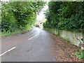
2
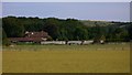
Farm buildings on the footpath to Torberry Hill
Torberry Hill, is visible behind the big tree, was an Iron Age Fort.
Image: © Dave Spicer
Taken: 20 Oct 2012
0.06 miles
3

Looking over Rape fields towards South Harting
Image: © Martyn Pattison
Taken: 10 May 2005
0.11 miles
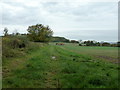
5
Road to West Harting
Off North Lane South Harting.
Image: © Dave Spicer
Taken: 20 Oct 2012
0.18 miles
6
The Manor House at South Harting
The manor house is seen here from the rear.
Image: © Shazz
Taken: 31 Jul 2009
0.22 miles
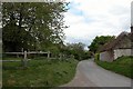
7
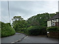
Lane junction between South and West Harting
Image: © Basher Eyre
Taken: 26 May 2014
0.22 miles
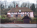
8
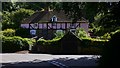
The Old Greyhound at West Harting
Was this once a public house? This cottage has been pictured before (http://www.geograph.org.uk/photo/357488) in the winter.
Image: © Shazz
Taken: 31 Jul 2009
0.23 miles
9
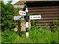
Old Direction Sign - Signpost by North Road, Harting parish
Pawn finial - 3 arms; West Sussex ball by the UC road, in parish of Harting (Chichester District), North Road, South Harting, on grass verge near wall.
Surveyed
Milestone Society National ID: SX_SU7820
Image: © Milestone Society
Taken: Unknown
0.23 miles
10
Old Greyhound Cottage near West Harting
Image: © Maigheach-gheal
Taken: 17 Feb 2007
0.24 miles