IMAGES TAKEN NEAR TO
Parsonage Estate, PETERSFIELD, GU31 5BF
Introduction
This page details the photographs taken nearby to Parsonage Estate, GU31 5BF by members of the Geograph project.
The Geograph project started in 2005 with the aim of publishing, organising and preserving representative images for every square kilometre of Great Britain, Ireland and the Isle of Man.

There are currently over 7.5m images from over14,400 individuals and you can help contribute to the project by visiting https://www.geograph.org.uk
Image Map
Images are licensed for reuse under creativecommons.org/licenses/by-sa/2.0
Notes
- Clicking on the map will re-center to the selected point.
- The higher the marker number, the further away the image location is from the centre of the postcode.
Image Listing (108 Images Found)
Images are licensed for reuse under creativecommons.org/licenses/by-sa/2.0
Image
Details
Distance
3
Alley from Rogate School to the Parsonage Estate
Image: © Basher Eyre
Taken: 3 May 2008
0.06 miles
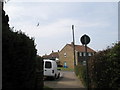
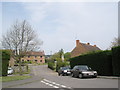
4
2016: a year on Geograph (Day 39)
Houses on the Parsonage Estate
Image: © Basher Eyre
Taken: 8 Feb 2016
0.06 miles
5
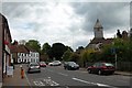
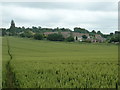
Rogate Village centre
The church of St Bartholomew on the right, the white building straight ahead is the White Horse Inn.
Image: © Martyn Pattison
Taken: 10 May 2005
0.06 miles
7
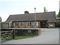
Rogate Primary School
Under threat of closure it would seem (May 2008).
Image: © Basher Eyre
Taken: 3 May 2008
0.07 miles
8
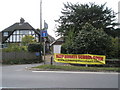
Heartfelt banner at Rogate
Everywhere I walked I saw these.
Image: © Basher Eyre
Taken: 3 May 2008
0.09 miles
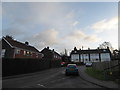
9
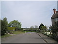
Junction of the Parsonage Estate with the A272
Image: © Basher Eyre
Taken: 3 May 2008
0.09 miles
10
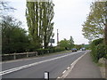
Looking westwards along the A272 at Rogate
Image: © Basher Eyre
Taken: 3 May 2008
0.10 miles