IMAGES TAKEN NEAR TO
Lower Wardown, PETERSFIELD, GU31 4PA
Introduction
This page details the photographs taken nearby to Lower Wardown, GU31 4PA by members of the Geograph project.
The Geograph project started in 2005 with the aim of publishing, organising and preserving representative images for every square kilometre of Great Britain, Ireland and the Isle of Man.

There are currently over 7.5m images from over14,400 individuals and you can help contribute to the project by visiting https://www.geograph.org.uk
Image Map
Images are licensed for reuse under creativecommons.org/licenses/by-sa/2.0
Notes
- Clicking on the map will re-center to the selected point.
- The higher the marker number, the further away the image location is from the centre of the postcode.
Image Listing (237 Images Found)
Images are licensed for reuse under creativecommons.org/licenses/by-sa/2.0
Image
Details
Distance
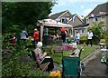
1
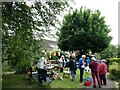
A platinum party at Lower Wardown (c)
With its lovely courtyard, where better to have a jubbily time?
Image: © Basher Eyre
Taken: 4 Jun 2022
0.00 miles
2
Path from River Walk to Moggs Mead: Christmas Day 2017
Image: © Basher Eyre
Taken: 25 Dec 2017
0.01 miles
3
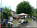
A platinum party at Lower Wardown (a)
SU 7580 2355 With its lovely courtyard, where better to have a jubbily time?
Image: © Basher Eyre
Taken: 4 Jun 2022
0.01 miles
4
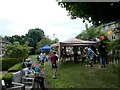
A platinum party at Lower Wardown (b)
With its lovely courtyard, where better to have a jubbily time?
Image: © Basher Eyre
Taken: 4 Jun 2022
0.01 miles
5
A platinum party at Lower Wardown (d)
With its lovely courtyard, where better to have a jubbily time?
Image: © Basher Eyre
Taken: 4 Jun 2022
0.01 miles
7
2016: a year on Geograph (Day 220)
The courtyard, Lower Wardown
Image: © Basher Eyre
Taken: 7 Aug 2016
0.02 miles
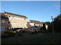
8
Communal Garden at Lower Wardown, Petersfield
On Herne Farm Estate within a courtyard of 1970s houses.
Image: © Basher Eyre
Taken: 27 Oct 2007
0.02 miles
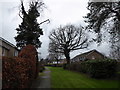
10
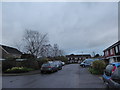
2016: a year on Geograph (Day 2)
Looking northwards up Lower Wardown
The Herne Farm housing estate began development in 1974. This is one of the earlier roads
Image: © Basher Eyre
Taken: 2 Jan 2016
0.03 miles