IMAGES TAKEN NEAR TO
Mansel Close, GUILDFORD, GU2 9RF
Introduction
This page details the photographs taken nearby to Mansel Close, GU2 9RF by members of the Geograph project.
The Geograph project started in 2005 with the aim of publishing, organising and preserving representative images for every square kilometre of Great Britain, Ireland and the Isle of Man.

There are currently over 7.5m images from over14,400 individuals and you can help contribute to the project by visiting https://www.geograph.org.uk
Image Map
Images are licensed for reuse under creativecommons.org/licenses/by-sa/2.0
Notes
- Clicking on the map will re-center to the selected point.
- The higher the marker number, the further away the image location is from the centre of the postcode.
Image Listing (23 Images Found)
Images are licensed for reuse under creativecommons.org/licenses/by-sa/2.0
Image
Details
Distance
1
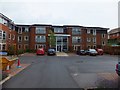
Queen Elizabeth Park Care Home
A purpose built private care home in a suburb of Guildford
Image: © David Smith
Taken: 20 Jul 2011
0.14 miles
2
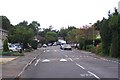
Cumberland Avenue, near Pitch Place, Guildford
Cumberland Avenue is part of a substantial suburban development created on the site of the Hazels, the sports ground of the Friary, Holroyd & Healy’s Brewery.
Image: © Ron Strutt
Taken: 24 Sep 2005
0.16 miles
3
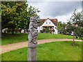
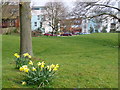
Wooden sculpture on the "village green" of Henderson Avenue
Image: © David Smith
Taken: 20 Jul 2011
0.17 miles
4
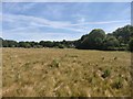
Grassland next to Salt Box Road
The outskirts of Guildford built up area.
Image: © James Emmans
Taken: 2 Jun 2020
0.18 miles
5
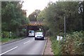
Low Bridge at Salt Box Road
When the railway was built across the heathland between Woking and Guildford the roads which it crossed were mere tracks. As a result, some of the bridges were built with very low headroom, and to take vehicles of any height at all, the roads had to be lowered beneath the bridges, with obvious potential for flooding.
Image: © Ron Strutt
Taken: 14 Sep 2005
0.19 miles

7

Stringer's Common
The sluice that carries the drainage ditch under the railway line
Image: © Alan Hunt
Taken: 13 Sep 2011
0.21 miles
8
Queen Elizabeth Park
Green space surrounded by new housing on a modern housing estate in Guildford. This is on the site of a former women's army barracks.
Image: © Colin Smith
Taken: 15 Mar 2008
0.21 miles
9
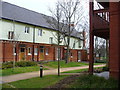
Terraced Housing, Queen Elizabeth Park
Modern housing on a new housing estate in north Guildford. This is the site of a former women's army barracks.
Image: © Colin Smith
Taken: 15 Mar 2008
0.22 miles
10
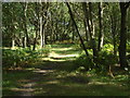
Stringer's Common
Woodland path near the railway line that marks the western edge of the common
Image: © Alan Hunt
Taken: 13 Sep 2011
0.22 miles