IMAGES TAKEN NEAR TO
GU29 1DE
Introduction
This page details the photographs taken nearby to GU29 1DE by members of the Geograph project.
The Geograph project started in 2005 with the aim of publishing, organising and preserving representative images for every square kilometre of Great Britain, Ireland and the Isle of Man.

There are currently over 7.5m images from over14,400 individuals and you can help contribute to the project by visiting https://www.geograph.org.uk
Image Map (Loading...)


Getting Data...Please wait
Leaflet Map data © OpenStreetMap
Images are licensed for reuse under creativecommons.org/licenses/by-sa/2.0
Notes
- Clicking on the map will re-center to the selected point.
- The higher the marker number, the further away the image location is from the centre of the postcode.
Image Listing (360 Images Found)
Images are licensed for reuse under creativecommons.org/licenses/by-sa/2.0
Image
Details
Distance
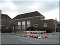
2
Veterinary Centre at entrance to public car park
Image: © Dave Spicer
Taken: 19 Jun 2011
0.01 miles
5
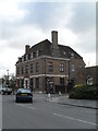
Midhurst Post Office
Taken in Grange Road.
Image: © Basher Eyre
Taken: 6 Mar 2010
0.02 miles
6
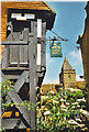
Midhurst
Ancient inn (Spread Eagle) with parish church behind.
Image: © Colin Smith
Taken: Unknown
0.02 miles
7
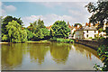
South Pond, Midhurst
Midhurst from the back road out of town to the south. The parish church is on the skyline.
Image: © Colin Smith
Taken: Unknown
0.02 miles
9
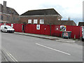
Redevelopment of The Old Court House, Grange Road
The board, attached to the hoarding above the bench, reads “a development of 1 and 2 bedroom apartments in the old house”.
Image: © John Baker
Taken: 8 Apr 2016
0.02 miles