IMAGES TAKEN NEAR TO
Hilltop, MIDHURST, GU29 0HT
Introduction
This page details the photographs taken nearby to Hilltop, GU29 0HT by members of the Geograph project.
The Geograph project started in 2005 with the aim of publishing, organising and preserving representative images for every square kilometre of Great Britain, Ireland and the Isle of Man.

There are currently over 7.5m images from over14,400 individuals and you can help contribute to the project by visiting https://www.geograph.org.uk
Image Map (Loading...)


Getting Data...Please wait
Leaflet Map data © OpenStreetMap
Images are licensed for reuse under creativecommons.org/licenses/by-sa/2.0
Notes
- Clicking on the map will re-center to the selected point.
- The higher the marker number, the further away the image location is from the centre of the postcode.
Image Listing (43 Images Found)
Images are licensed for reuse under creativecommons.org/licenses/by-sa/2.0
Image
Details
Distance
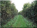
1
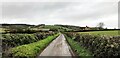
Middlefield Lane heading west
This lane forms part of the South Downs Way. The buildings in the middle distance are at Cocking Hill Farm. The hill in the far distance is Cocking Down.
Image: © Ian Hawfinch
Taken: 24 Oct 2020
0.02 miles
2
View west along Middlefield Lane
The South Downs Way runs along this lane, which turns into a track as it approaches Cocking Down. The outbuilding on the left belongs to Cocking Hill Farm.
Image: © Ian Hawfinch
Taken: 24 Oct 2020
0.02 miles
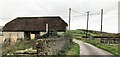
3
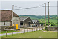
Hilltop power supply
The sagging cable suspended from the two posts is spliced off the more level cable supported by the right-hand post, and supplies the barns on the left. The more level cable is supplied from a transformer on the next post to the left of the medium voltage line with the birds on (probably starlings). It continues to the right to supply a farmhouse.
Image: © Robin Webster
Taken: 25 Oct 2011
0.02 miles
4
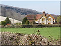
Hilltop, Above Cocking
One of many cottages in this area with the bright yellow livery of the Cowdray Estate.
http://www.gravelroots.net/cocking/cocking.html
Image: © Colin Smith
Taken: 6 Apr 2012
0.03 miles
6
Middlefield Lane (the South Downs Way) at Cocking Hill Dairy
View eastwards, towards the A 286 and - beyond - Manorfarm Down. The dairy is part of the Cowdray Park estate.
Image: © Stefan Czapski
Taken: 28 Aug 2015
0.05 miles
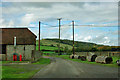
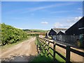
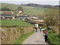
8
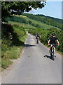
Track from Hilltop farm
Riders in the 2015 British Heart Foundation's event crossing the full 100-mile length of the South Downs Way, braking hard to the giveway with the A286 Cocking Hill road.
Image: © Richard Law
Taken: 18 Jul 2015
0.09 miles
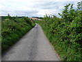
9
Restricted Byway north from Middlefield Lane
Middlefield Lane is part of the South downs Way.
Image: © Dave Spicer
Taken: 2 Oct 2010
0.09 miles
10
Hillbarn Lane, South Downs Way
Descending to the main Chichester-Midhurst Road at the top of Cocking Hill. The South Downs Way ascends the hillside in the distance, following the ridgeway.
Image: © Colin Smith
Taken: 6 Apr 2012
0.10 miles