IMAGES TAKEN NEAR TO
Lickfold, PETWORTH, GU28 9EY
Introduction
This page details the photographs taken nearby to GU28 9EY by members of the Geograph project.
The Geograph project started in 2005 with the aim of publishing, organising and preserving representative images for every square kilometre of Great Britain, Ireland and the Isle of Man.

There are currently over 7.5m images from over14,400 individuals and you can help contribute to the project by visiting https://www.geograph.org.uk
Image Map
Images are licensed for reuse under creativecommons.org/licenses/by-sa/2.0
Notes
- Clicking on the map will re-center to the selected point.
- The higher the marker number, the further away the image location is from the centre of the postcode.
Image Listing (35 Images Found)
Images are licensed for reuse under creativecommons.org/licenses/by-sa/2.0
Image
Details
Distance
1
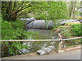
Major repairs to stream at Lickfold bridge
Image: © Dave Spicer
Taken: 16 May 2010
0.02 miles
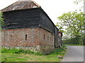
2
Barns, Gentils Farm, Lickfold Road
The barns date back to the 18th century.
Image: © Simon Carey
Taken: 11 Aug 2024
0.03 miles
4
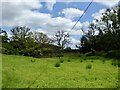
The Mead
The name of the field according to Lodsworth's 1841 tithe map that is bounded by Lickfold Road to the south and the River Lod to the east.
Image: © Simon Carey
Taken: 11 Aug 2024
0.04 miles
5
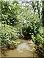
River Lod
A tributary of the River Rother that rises near Haslemere and joins the river south of Halfway Bridge.
Image: © Simon Carey
Taken: 11 Aug 2024
0.05 miles
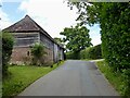
6
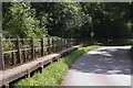
Lickfold
Approaching from the north, this bit of road is liable to flooding, hence the raised footway.
Image: © Ben Gamble
Taken: 21 Aug 2005
0.06 miles
7
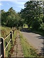
Road across the flood-plain at Lickfold Bridge
Photo taken from the narrow raised causeway provided because at times the river flows over the road. It's not clear from the OS mapping whether the stream here is officially the Rother, or reckoned to be a tributary.
Image: © Stefan Czapski
Taken: 19 Jul 2015
0.06 miles
8
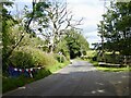
Lickfold Bridge
Carrying Surrey Road over the River Lod.
Image: © Simon Carey
Taken: 11 Aug 2024
0.06 miles
9

Direction Sign - Signpost at Lickford Bridge in Lodsworth
Annulus finial - 3 arms; WSCC parish halo by the UC road, in parish of Lodsworth (Chichester District), on the northwest side of a T junction at Lickfold Bridge.
surveyed
Milestone Society National ID: SX_SU9226B
Image: © A Savill
Taken: 20 Jul 2014
0.06 miles
10
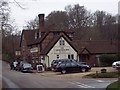
The Lickfold Inn
The inn is 15th century.
Image: © Maigheach-gheal
Taken: 18 Feb 2007
0.07 miles