IMAGES TAKEN NEAR TO
Lodsworth, PETWORTH, GU28 9BX
Introduction
This page details the photographs taken nearby to GU28 9BX by members of the Geograph project.
The Geograph project started in 2005 with the aim of publishing, organising and preserving representative images for every square kilometre of Great Britain, Ireland and the Isle of Man.

There are currently over 7.5m images from over14,400 individuals and you can help contribute to the project by visiting https://www.geograph.org.uk
Image Map
Images are licensed for reuse under creativecommons.org/licenses/by-sa/2.0
Notes
- Clicking on the map will re-center to the selected point.
- The higher the marker number, the further away the image location is from the centre of the postcode.
Image Listing (8 Images Found)
Images are licensed for reuse under creativecommons.org/licenses/by-sa/2.0
Image
Details
Distance
1
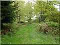
Bridleway 3348 towards Heath End Lane
The bridleway runs along the parish boundary between Easebourne (right) and Lodsworth.
Image: © Robin Webster
Taken: 11 May 2012
0.09 miles
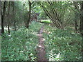
2
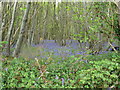
Bridleway 3348 around Heathend Copse
The bridleway runs along the parish boundary between Easebourne (left) and Lodsworth, with the copse on the right.
Image: © Robin Webster
Taken: 11 May 2012
0.12 miles
3
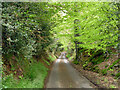
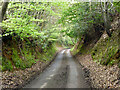
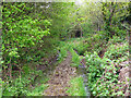
Heath End Lane
Deeply sunken, characteristic of lanes on softer wealden sandstones on slopes where past traffic and water has shuffled sand downhill. The modern tarmac must largely arrest this process.
Image: © Robin Webster
Taken: 11 May 2012
0.12 miles
5
Heath End Lane
Deeply sunken, characteristic of lanes on softer wealden sandstones on slopes where past traffic and water has shuffled sand downhill. The modern tarmac must largely arrest this process.
Image: © Robin Webster
Taken: 11 May 2012
0.18 miles
7
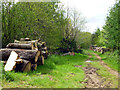
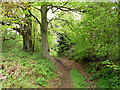
Track and timber, Heathend Copse
The track parallels the public lane to the left.
Image: © Robin Webster
Taken: 11 May 2012
0.24 miles
8
Bridleway 3348 around Heathend Copse
The bridleway runs along the parish boundary between Easebourne (left) and Lodsworth, with the copse on the right.
Image: © Robin Webster
Taken: 11 May 2012
0.24 miles