IMAGES TAKEN NEAR TO
Graffham, PETWORTH, GU28 0QF
Introduction
This page details the photographs taken nearby to GU28 0QF by members of the Geograph project.
The Geograph project started in 2005 with the aim of publishing, organising and preserving representative images for every square kilometre of Great Britain, Ireland and the Isle of Man.

There are currently over 7.5m images from over14,400 individuals and you can help contribute to the project by visiting https://www.geograph.org.uk
Image Map
Images are licensed for reuse under creativecommons.org/licenses/by-sa/2.0
Notes
- Clicking on the map will re-center to the selected point.
- The higher the marker number, the further away the image location is from the centre of the postcode.
Image Listing (7 Images Found)
Images are licensed for reuse under creativecommons.org/licenses/by-sa/2.0
Image
Details
Distance
1
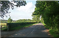
Country road near Graffham (3)
Looking north-east in the direction of Petworth (though this road doesn't directly go there).
Woodland at Graffham Common is just visible on the far left.
Image: © Stephen Richards
Taken: Unknown
0.13 miles
3
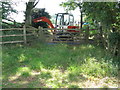
Mechanical barrier at gateway near Upper Norwood
Image: © Dave Spicer
Taken: 26 Jun 2010
0.16 miles
4
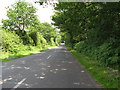
NE on lane from Graffham to Lavington Common
Image: © Dave Spicer
Taken: 26 Jun 2010
0.21 miles
5
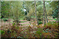
Woodland, Upper Norwood
An area subject to a fire a few years earlier.
Image: © Robin Webster
Taken: 13 Oct 2010
0.23 miles
6
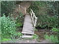
Footbridge at start of climb from stream
Image: © Dave Spicer
Taken: 26 Jun 2010
0.24 miles
7
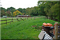
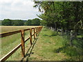
Paddocks at edge of woodland, Upper Norwood
Image: © Robin Webster
Taken: 13 Oct 2010
0.25 miles