IMAGES TAKEN NEAR TO
/High Street, PETWORTH, GU28 0LT
Introduction
This page details the photographs taken nearby to /High Street, GU28 0LT by members of the Geograph project.
The Geograph project started in 2005 with the aim of publishing, organising and preserving representative images for every square kilometre of Great Britain, Ireland and the Isle of Man.

There are currently over 7.5m images from over14,400 individuals and you can help contribute to the project by visiting https://www.geograph.org.uk
Image Map
Images are licensed for reuse under creativecommons.org/licenses/by-sa/2.0
Notes
- Clicking on the map will re-center to the selected point.
- The higher the marker number, the further away the image location is from the centre of the postcode.
Image Listing (18 Images Found)
Images are licensed for reuse under creativecommons.org/licenses/by-sa/2.0
Image
Details
Distance

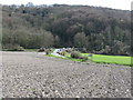
2
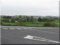
View across loop in road to houses near Manor Farm
Image: © Dave Spicer
Taken: 11 Apr 2009
0.05 miles
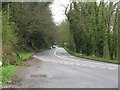
3
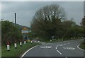
Beechwood Lane, Duncton
The lane leads off to the left of the A285 at a bend on the edge of the village
Image: © David Smith
Taken: 28 Apr 2014
0.06 miles
4
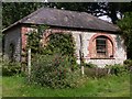
Outbuilding at Manor Farm
The first photograph of this building was submitted four months earlier (http://www.geograph.org.uk/photo/1806873 ). Onions have now been added.
Image: © Shazz
Taken: 2 Sep 2010
0.06 miles
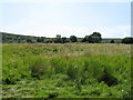
5
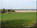
View from the lower slopes of Fryan's Hanger
The white building to the right of centre is Burton Park.
Image: © Dave Spicer
Taken: 10 Apr 2010
0.12 miles
6
The A285 at the bottom of Duncton Hill
Duncton Hanger provides the background.
Image: © Dave Spicer
Taken: 10 Apr 2010
0.13 miles
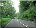
8
Sharp bend in road
The A285 climbs up Duncton Hill. 1/2 kilometre further up, on the right, a car park offers view across the weald to the North Downs
Image: © Dave Spicer
Taken: 11 Apr 2009
0.17 miles
10

Dunction Hill Viewpoint
There is a small car park where a splendid view is offered over the South Downs National Park. The small town of Petworth can be seen to the right in the distance.
Image: © G Laird
Taken: 16 Jul 2019
0.21 miles