IMAGES TAKEN NEAR TO
Hammer Hill, HASLEMERE, GU27 3QZ
Introduction
This page details the photographs taken nearby to Hammer Hill, GU27 3QZ by members of the Geograph project.
The Geograph project started in 2005 with the aim of publishing, organising and preserving representative images for every square kilometre of Great Britain, Ireland and the Isle of Man.

There are currently over 7.5m images from over14,400 individuals and you can help contribute to the project by visiting https://www.geograph.org.uk
Image Map
Images are licensed for reuse under creativecommons.org/licenses/by-sa/2.0
Notes
- Clicking on the map will re-center to the selected point.
- The higher the marker number, the further away the image location is from the centre of the postcode.
Image Listing (8 Images Found)
Images are licensed for reuse under creativecommons.org/licenses/by-sa/2.0
Image
Details
Distance
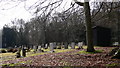
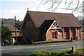
3
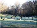
Hammer burial ground
'Children under 14 visiting the burial ground must be accompanied by a responsible adult person', according to a sign at the entrance.
Image: © Robin Webster
Taken: 20 Jan 2016
0.12 miles
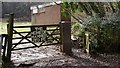
4
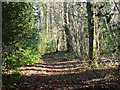
Footpath to Hammer
Starting from the end of Gillham's Lane.
Image: © Robin Webster
Taken: 20 Jan 2016
0.13 miles
6
Hammer United Football Club
Here we see the entrance, clubhouse a viewing shelter in the background and the remains of snowmen on the pitch.
Image: © Shazz
Taken: 12 Feb 2009
0.21 miles
7
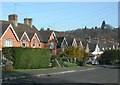
Heath Road, Hammer
Taken from SU875322, looking north down the road.
Image: © Ben Gamble
Taken: 16 Apr 2005
0.24 miles
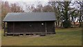
8
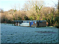
Pavilion, Hammer United FC
The pitch is a bit on the hard side today.
Image: © Robin Webster
Taken: 20 Jan 2016
0.25 miles