IMAGES TAKEN NEAR TO
Copyhold Lane, HASLEMERE, GU27 3DZ
Introduction
This page details the photographs taken nearby to Copyhold Lane, GU27 3DZ by members of the Geograph project.
The Geograph project started in 2005 with the aim of publishing, organising and preserving representative images for every square kilometre of Great Britain, Ireland and the Isle of Man.

There are currently over 7.5m images from over14,400 individuals and you can help contribute to the project by visiting https://www.geograph.org.uk
Image Map
Images are licensed for reuse under creativecommons.org/licenses/by-sa/2.0
Notes
- Clicking on the map will re-center to the selected point.
- The higher the marker number, the further away the image location is from the centre of the postcode.
Image Listing (12 Images Found)
Images are licensed for reuse under creativecommons.org/licenses/by-sa/2.0
Image
Details
Distance
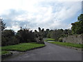
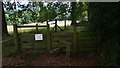
3
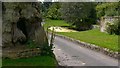
Footpath to Fernhurst
The footpath is to the right. The road across the front of the picture runs between Copyhold Hill (left) and the A286 (right).
Image: © Shazz
Taken: 20 Mar 2009
0.10 miles
5
Searching southwards down the Bashire (4)
Upper Sopers
Running total: 5 B points
Image: © Basher Eyre
Taken: 13 Oct 2016
0.11 miles
6
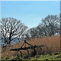
Abandoned equipment north of Sopers Barn Farm
Image: © Ian Hawfinch
Taken: 7 Mar 2022
0.11 miles
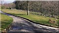
8
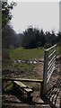
Footpath from Copyhold Lane to Old Glebe, Fernhurst
The footpath starts here and is about half a mile long.
Image: © Shazz
Taken: 20 Mar 2009
0.13 miles
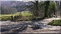
9
Footpath to Fernhurst
A car was being driven around the field.
Image: © Shazz
Taken: 27 Aug 2009
0.15 miles
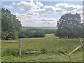
10
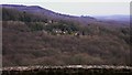
Houses on Haslemere Road near Fernhurst
Haslemere Road is the A286. Black Down is the high ground on the left.
Image: © Shazz
Taken: 16 Feb 2009
0.19 miles