IMAGES TAKEN NEAR TO
Upper Walk, VIRGINIA WATER, GU25 4SN
Introduction
This page details the photographs taken nearby to Upper Walk, GU25 4SN by members of the Geograph project.
The Geograph project started in 2005 with the aim of publishing, organising and preserving representative images for every square kilometre of Great Britain, Ireland and the Isle of Man.

There are currently over 7.5m images from over14,400 individuals and you can help contribute to the project by visiting https://www.geograph.org.uk
Image Map
Images are licensed for reuse under creativecommons.org/licenses/by-sa/2.0
Notes
- Clicking on the map will re-center to the selected point.
- The higher the marker number, the further away the image location is from the centre of the postcode.
Image Listing (49 Images Found)
Images are licensed for reuse under creativecommons.org/licenses/by-sa/2.0
Image
Details
Distance
1
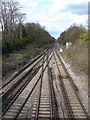
Railway, Virginia Water
A view north from the bridge on Christchurch Road. The rails are disappearing off in the direction of Egham and Staines. The points in the foreground are where the line splits towards Chertsey or Sunningdale.
Image: © Alan Hunt
Taken: 5 Apr 2010
0.05 miles
2
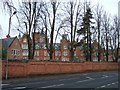
Virginia Park
The old Holloway Sanatorium, viewed from the side in Stroude Road
Image: © Martyn Davies
Taken: 9 Mar 2006
0.05 miles
3
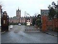
Gates onto Stroude Road
Closing off your road with big gates is quite fashionable round here.
I sometimes wish we could do it down our road, except I know I'd forget the entry code....
Image: © Des Blenkinsopp
Taken: 6 Apr 2017
0.08 miles
4
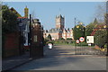
Virginia Park
This grand Victorian building was the Holloway Sanatorium, but it closed in 1981. After a period of neglect and disrepair, it was converted into a large private housing estate in about 1996.
Image: © Martyn Davies
Taken: 9 Mar 2006
0.08 miles
5
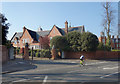
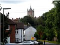
The Old Sanatorium
The former Holloway Sanatorium was built between 1873 - 1885 under the patronage of Thomas Holloway, a wealthy philanthropist who had made a fortune from Patent Medicines.
Following closure by the NHS it was converted to housing and is now called Virginia Park.
Wiki. page on Holloway Sanatorium :- https://en.wikipedia.org/wiki/Holloway_Sanatorium
Only the gates are in this square, the buildings are in TQ0068.
Image: © Des Blenkinsopp
Taken: 6 Apr 2017
0.09 miles
6
Virginia Water and tower of Holloway Sanatorium
The tower belongs to the former Holloway Sanatorium (Psychiatric hospital) which was built 1873-75. The architect was William Crossland and it was paid for by Thomas Holloway. The same architect and benefactor are responsible for nearby Royal Holloway College. The hospital is now a gated housing estate.
Image: © Bikeboy
Taken: 13 Jul 2014
0.09 miles
8
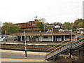
Virginia Water station buildings
The station is 2km from the lake whose name it bears. The present uninspiring buildings look like standard British Rail design from the 1960s or 1970s.
Image: © Stephen Craven
Taken: 12 Apr 2014
0.10 miles
9
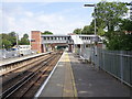
Virginia Water railway station, Surrey
Opened in 1856 by the London & South Western Railway on the line from Staines to Reading.
View north towards Egham and Staines. These platforms are for Staines and Reading, the two to the right are for the Weybridge line, which opened in 1866. The footbridge was new in 2018. See Image for a 2011 view in the opposite direction from the old footbridge.
Image: © Nigel Thompson
Taken: 8 Jul 2019
0.11 miles
10
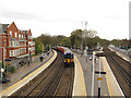
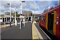
Slow train to Waterloo
Class 455 electric multiple unit no. 5857 waits on platform 3 of Virginia Water station to form the 15.24 stopping service to London Waterloo via Hounslow which takes over an hour for the 22 mile journey. Services from platform 3 on the route from Reading via Richmond are considerably quicker.
Image: © Stephen Craven
Taken: 12 Apr 2014
0.11 miles