IMAGES TAKEN NEAR TO
Pipers End, VIRGINIA WATER, GU25 4AW
Introduction
This page details the photographs taken nearby to Pipers End, GU25 4AW by members of the Geograph project.
The Geograph project started in 2005 with the aim of publishing, organising and preserving representative images for every square kilometre of Great Britain, Ireland and the Isle of Man.

There are currently over 7.5m images from over14,400 individuals and you can help contribute to the project by visiting https://www.geograph.org.uk
Image Map
Images are licensed for reuse under creativecommons.org/licenses/by-sa/2.0
Notes
- Clicking on the map will re-center to the selected point.
- The higher the marker number, the further away the image location is from the centre of the postcode.
Image Listing (4 Images Found)
Images are licensed for reuse under creativecommons.org/licenses/by-sa/2.0
Image
Details
Distance
2
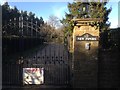
New Pipers Gates, Gorse Hill Road
The gates to New Pipers, the property at the end of Gorse Hill Road, Virginia Water.
Image: © Ajay Tegala
Taken: 6 Mar 2015
0.14 miles
3
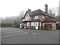
Bed and breakfast on Stroude Road
This clearly used to be a pub, and now has a large car park it probably never needs.
Image: © David Howard
Taken: 13 Dec 2015
0.24 miles
4
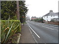
Stroude Road
Stroude is a village strung out along the road from Virginia Water to Englefield Green, so unless you're making that journey you'd never pass through it, as I hadn't till now.
Image: © David Howard
Taken: 13 Dec 2015
0.25 miles