IMAGES TAKEN NEAR TO
Commonfields, WOKING, GU24 9HZ
Introduction
This page details the photographs taken nearby to Commonfields, GU24 9HZ by members of the Geograph project.
The Geograph project started in 2005 with the aim of publishing, organising and preserving representative images for every square kilometre of Great Britain, Ireland and the Isle of Man.

There are currently over 7.5m images from over14,400 individuals and you can help contribute to the project by visiting https://www.geograph.org.uk
Image Map
Images are licensed for reuse under creativecommons.org/licenses/by-sa/2.0
Notes
- Clicking on the map will re-center to the selected point.
- The higher the marker number, the further away the image location is from the centre of the postcode.
Image Listing (52 Images Found)
Images are licensed for reuse under creativecommons.org/licenses/by-sa/2.0
Image
Details
Distance
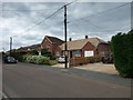
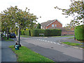
5
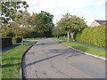
Jenner Drive, West End
Looking north along Jenner Drive towards the junction with Commonfields.
Image: © Alan Hunt
Taken: 8 Oct 2014
0.06 miles
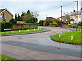
7
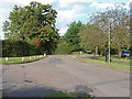
Staggered junction, Jenner Drive
Jenner Drive with Commonfields on the left and the north end of Barnsfield Crescent on the right.
Image: © Alan Hunt
Taken: 8 Oct 2014
0.07 miles
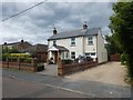
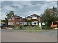
8
Westend, Surrey
The view along Benner Lane showing the junction with Malthouse Lane
Image: © Alan Hunt
Taken: 11 Apr 2010
0.08 miles
9
Jenner Drive, West End
Jenner Lane looking towards the junction with Barnsford Crescent.
Image: © Alan Hunt
Taken: 8 Oct 2014
0.08 miles
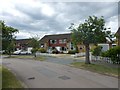
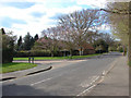
10
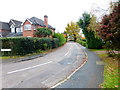
Looking along Commonfields from the northern end
Image: © Shazz
Taken: 13 Nov 2014
0.08 miles