IMAGES TAKEN NEAR TO
Windsor Road, WOKING, GU24 8LE
Introduction
This page details the photographs taken nearby to Windsor Road, GU24 8LE by members of the Geograph project.
The Geograph project started in 2005 with the aim of publishing, organising and preserving representative images for every square kilometre of Great Britain, Ireland and the Isle of Man.

There are currently over 7.5m images from over14,400 individuals and you can help contribute to the project by visiting https://www.geograph.org.uk
Image Map
Images are licensed for reuse under creativecommons.org/licenses/by-sa/2.0
Notes
- Clicking on the map will re-center to the selected point.
- The higher the marker number, the further away the image location is from the centre of the postcode.
Image Listing (37 Images Found)
Images are licensed for reuse under creativecommons.org/licenses/by-sa/2.0
Image
Details
Distance
1
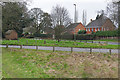
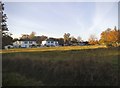
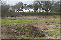
Burrowhill, Chobham
Looking across Little Heath Road towards the houses on the Windsor Road in the Burrowhill area of Chobham.
Image: © Alan Hunt
Taken: 12 Feb 2016
0.07 miles
2
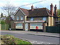
Burrow Hill Bakery
Local shop on the southern edge of the triangular green at Burrowhill, Chobham.
Image: © Colin Smith
Taken: 11 Apr 2010
0.08 miles
3
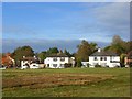
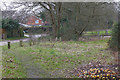
Burrowhill Green, Chobham
Looking across the green, part of Chobham's extensive common lands, from the B383 Windsor Road.
Image: © Andrew Smith
Taken: 19 Oct 2008
0.10 miles
4
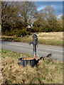
Burrowhill Green
Old water pump beside the B383 on Burrowhill Green
Image: © Alan Hunt
Taken: 20 Feb 2010
0.10 miles
5
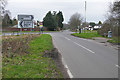
Crossroards, Burrowhill
The crossroads where the Red Lion Road (foreground) and the Windlesham Road (background) meet the Windsor Road.
Image: © Alan Hunt
Taken: 12 Feb 2016
0.11 miles
6
Sandy Lane, Chobham
The patch of common land beside Sandy Lane in the Burrowhill area of Chobham.
Image: © Alan Hunt
Taken: 12 Feb 2016
0.12 miles
8
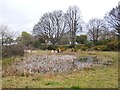
Pond on Burrow Hill Green, Chobham
A photo taken in rain. Alan Hunt, who knows the area better than I do, has pointed out that this pond tends to dry up in summer http://www.geograph.org.uk/photo/1717833. The first two weeks of April 2012 turned out quite rainy - in contrast to the early months of the year, and brought some relief from a spell of dry weather which had lasted many months. Considering the circumstances, the pond didn't appear to be doing too badly.
This pond lies close to a road - the Chobham-Sunningdale road runs just the other side of the trees. This, I think, gives a clue to the pond's original function. In contrast to another local pond Image this - I suspect - was a horse pond, where draught-horses, trudging uphill in warm weather, could wade in and cool off - and have a drink.
Image: © Stefan Czapski
Taken: 11 Apr 2012
0.13 miles
9
Burrowhill Green, Chobham
The patch of heath in the Burrowhill area of Chobham with the houses along the Windlesham Road in the background.
Image: © Alan Hunt
Taken: 12 Feb 2016
0.13 miles
10
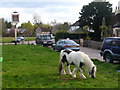
Four Horseshoes and Four Horseshoes
Carthorse on Burrow Hill Green by the Four Horseshoes pub.
Image: © Colin Smith
Taken: 11 Apr 2010
0.13 miles