IMAGES TAKEN NEAR TO
Manor Crescent, WOKING, GU24 0PD
Introduction
This page details the photographs taken nearby to Manor Crescent, GU24 0PD by members of the Geograph project.
The Geograph project started in 2005 with the aim of publishing, organising and preserving representative images for every square kilometre of Great Britain, Ireland and the Isle of Man.

There are currently over 7.5m images from over14,400 individuals and you can help contribute to the project by visiting https://www.geograph.org.uk
Image Map
Images are licensed for reuse under creativecommons.org/licenses/by-sa/2.0
Notes
- Clicking on the map will re-center to the selected point.
- The higher the marker number, the further away the image location is from the centre of the postcode.
Image Listing (117 Images Found)
Images are licensed for reuse under creativecommons.org/licenses/by-sa/2.0
Image
Details
Distance
1
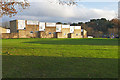
Army housing
1960s housing blocks off Billesden Road in the Army housing estate near Pirbright Barracks.
Image: © Alan Hunt
Taken: 7 Dec 2015
0.03 miles
2
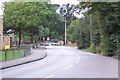
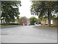
Pirbright Camp entrance
The entrance to Pirbright Camp, looking west into the camp. Pirbright is now home to one of the four Army Training Regiments: it trains recruits for The Household Cavalry, The Royal Logistic Corps, the Royal Electrical and Mechanical Engineers and the Royal Artillery. It was formerly home to the Guards and also the Gurkhas. Until a few years ago it was possible for civilians to drive straight through the camp from Brookwood to Deepcut but with the increased need for security entry to the camp is no longer permitted.
Image: © Ron Strutt
Taken: 28 Sep 2005
0.06 miles
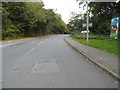
4
Brunswick Road, Pirbright
Looking east along Brunswick Road towards the junction with Heather Walk in the Army housing estate. This section of Brunswick road was constructed in the early 1980s along the southern boundary of the estate.
Image: © Alan Hunt
Taken: 7 Dec 2015
0.07 miles
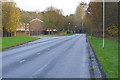
5
Sheets Heath access road
The junction of the unmade access road to Sheets Heath with Billesden Road near the Army housing estate.
Image: © Alan Hunt
Taken: 7 Dec 2015
0.09 miles
6
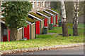
Red MOD doors, Billesden Road
A line of red doors standing to attention in the Army housing estate off Billesden Road near Pirbright.
Image: © Alan Hunt
Taken: 7 Dec 2015
0.09 miles
7
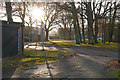
Slade Road, Pirbright
The junction between Slade Road and Billesden Road in the Army housing estate to the east of the Pirbright Barracks.
Image: © Alan Hunt
Taken: 7 Dec 2015
0.10 miles
9
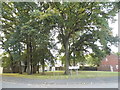
Trees on the corner of Slade Road and Billesden Road
Image: © David Howard
Taken: 9 Oct 2016
0.12 miles
10
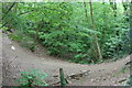
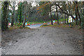
Trackbed of the old Bisley Camp railway
The Bisley Camp branch line closed in 1952. This section of line running parallel to Queens Road, now complete with mature trees, had steep embankments either side which are enjoyed as a stunt cycle track by local children.
Image: © Paul E Smith
Taken: 9 May 2009
0.12 miles