IMAGES TAKEN NEAR TO
Ash Road, WOKING, GU24 0NF
Introduction
This page details the photographs taken nearby to Ash Road, GU24 0NF by members of the Geograph project.
The Geograph project started in 2005 with the aim of publishing, organising and preserving representative images for every square kilometre of Great Britain, Ireland and the Isle of Man.

There are currently over 7.5m images from over14,400 individuals and you can help contribute to the project by visiting https://www.geograph.org.uk
Image Map
Images are licensed for reuse under creativecommons.org/licenses/by-sa/2.0
Notes
- Clicking on the map will re-center to the selected point.
- The higher the marker number, the further away the image location is from the centre of the postcode.
Image Listing (32 Images Found)
Images are licensed for reuse under creativecommons.org/licenses/by-sa/2.0
Image
Details
Distance
1
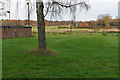
View from Upper Stanford Road
Looking east from Upper Stanford Road across the fields towards Bullswater Common. The building on the left is a garage block on Upper Stanford Road.
Image: © Alan Hunt
Taken: 3 Dec 2015
0.04 miles
2
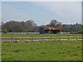
Farmland near Pirbright
Looking across the farmland between the Ash Road and Pirbright Village.
Image: © Alan Hunt
Taken: 28 Apr 2013
0.05 miles
3
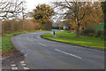
Ash Road, Pirbright
Looking east along the Ash Road from the junction with Upper Stanford Road.
Image: © Alan Hunt
Taken: 3 Dec 2015
0.06 miles
4
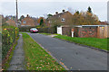
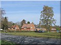
Upper Stanford Road
A small residential enclave based around a cul-de-sac off the Ash Road near Pirbright.
Image: © Alan Hunt
Taken: 3 Dec 2015
0.07 miles
5
Ash Road, Pirbright
Houses near the junction of Upper Stanford Road.
Image: © Alan Hunt
Taken: 28 Apr 2013
0.07 miles
6
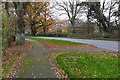
Walkway along the Ash Road
The walkway along the Ash Road, a rural road running from the Aldershot Road past Bullswater Common to Fox Corner on the A322.
Image: © Alan Hunt
Taken: 3 Dec 2015
0.10 miles
8
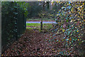
Path junction with the Ash Road
The southern end of the path from the Aldershot Road to the Ash Road. The path continues on the other side of the Ash Road across Cobbetthill Common.
Image: © Alan Hunt
Taken: 3 Dec 2015
0.13 miles
10
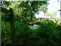
Footpath from the Ash Road
The footpath running behind the houses on Upper Stanford Road to the Aldershot Road.
Image: © Alan Hunt
Taken: 3 Dec 2015
0.14 miles