IMAGES TAKEN NEAR TO
Clandon Road, WOKING, GU23 7LA
Introduction
This page details the photographs taken nearby to Clandon Road, GU23 7LA by members of the Geograph project.
The Geograph project started in 2005 with the aim of publishing, organising and preserving representative images for every square kilometre of Great Britain, Ireland and the Isle of Man.

There are currently over 7.5m images from over14,400 individuals and you can help contribute to the project by visiting https://www.geograph.org.uk
Image Map
Images are licensed for reuse under creativecommons.org/licenses/by-sa/2.0
Notes
- Clicking on the map will re-center to the selected point.
- The higher the marker number, the further away the image location is from the centre of the postcode.
Image Listing (35 Images Found)
Images are licensed for reuse under creativecommons.org/licenses/by-sa/2.0
Image
Details
Distance
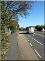
1
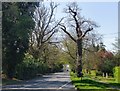
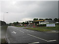
Clandon Road (A248), Burntcommon
Looking north-west towards Send. Immediately behind the camera a bridge carries the A248 over the A3.
Image: © Stefan Czapski
Taken: 15 Apr 2015
0.04 miles
4
Burntcommon - Field Way
Public footpath to the A247 Clandon Road,
Image: © James Emmans
Taken: 19 Nov 2018
0.06 miles
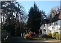
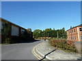
6
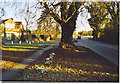
Clandon Road, Burnt Common.
Residential area in a commuter village east of Guildford with good road connections to the busy A3. This is taken looking south towards the bridge across the A3.
Image: © Colin Smith
Taken: Unknown
0.07 miles
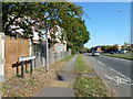
8
Looking from Portsmouth Road towards Milestone House
Image: © Basher Eyre
Taken: 15 Oct 2011
0.07 miles
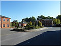
10
Looking from Milestone House towards Portsmouth Road
Image: © Basher Eyre
Taken: 15 Oct 2011
0.08 miles