IMAGES TAKEN NEAR TO
Potters Lane, WOKING, GU23 7AL
Introduction
This page details the photographs taken nearby to Potters Lane, GU23 7AL by members of the Geograph project.
The Geograph project started in 2005 with the aim of publishing, organising and preserving representative images for every square kilometre of Great Britain, Ireland and the Isle of Man.

There are currently over 7.5m images from over14,400 individuals and you can help contribute to the project by visiting https://www.geograph.org.uk
Image Map
Images are licensed for reuse under creativecommons.org/licenses/by-sa/2.0
Notes
- Clicking on the map will re-center to the selected point.
- The higher the marker number, the further away the image location is from the centre of the postcode.
Image Listing (45 Images Found)
Images are licensed for reuse under creativecommons.org/licenses/by-sa/2.0
Image
Details
Distance
1
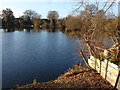
Send fishing lakes
The private fishing lakes off Potters Lane in Send.
Image: © Alan Hunt
Taken: 17 Dec 2012
0.06 miles
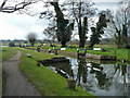
2
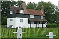
House at Worsfold Flood Gates
This house is contemporary with the canal, but I am not sure what it is used for today. The area is the main National Trust maintenance yard for the navigation, so perhaps it is offices or a private house.
Image: © Graham Horn
Taken: 25 Aug 2008
0.11 miles
3
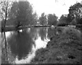
Above Worsfold Gates, River Wey, Surrey
The peaceful sylvan scene above Worsfold Gates in 1974. A barge (even then an infrequent sight on the river) lies against the offside bank.
Image: © Dr Neil Clifton
Taken: 27 Apr 1974
0.13 miles
4
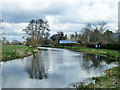
River Wey above Worsfold Gates
Here the navigation uses the natural river.
Image: © Robin Webster
Taken: 18 Mar 2012
0.13 miles
5
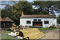
Woodyard at Worsfold
Logs and poles in a yard beside Worsfold flood gates.
Image: © Des Blenkinsopp
Taken: 3 May 2023
0.14 miles
6
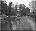
Worsfold Gates, Wey Navigation
See Image A long and complex series of weir streams leave just below these gates, part of the flow entering Broadmead Cut, an earlier route of the navigation.
Image: © Dr Neil Clifton
Taken: 14 Apr 1982
0.14 miles
7

Worsfold Gates on the Wey Navigation
Worsfold Gates, near Send, are only provided in case the river is in flood and normally both sets of gates are left open. The Dutch barge in the foreground is the Nemesis, owned by the Navigation's Maintenance Foreman.
Image: © Ron Strutt
Taken: 2 Oct 2005
0.14 miles
8
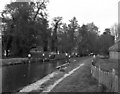
Worsfold Gates, River Wey, Surrey
Worsforld Gates are normally left open, as here, for unimpeded navigation. They are only used when abnormal conditions make it necessary to control water levels.
Image: © Dr Neil Clifton
Taken: 27 Apr 1974
0.14 miles
9
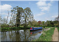
Cruising up the Wey
Heading towards Guildford on a beautiful afternoon in early May.
Incidentally, this boat is called "Itchen To Go," a pun on the name of the river through Winchester, which used to be navigable in days gone by.
Image: © Des Blenkinsopp
Taken: 3 May 2023
0.14 miles
10
Worsfold Gates, Wey Navigation
A flood lock where the navigation leaves the river. Normally both sets of gates are open, as here. The paddle gear is primitive, it appears they have to be raised by physically lifting them. Levering with a crowbar has been mentioned, but how is not obvious.
Image: © Robin Webster
Taken: 18 Mar 2012
0.15 miles