IMAGES TAKEN NEAR TO
Liquorice Lane, WOKING, GU22 9NY
Introduction
This page details the photographs taken nearby to Liquorice Lane, GU22 9NY by members of the Geograph project.
The Geograph project started in 2005 with the aim of publishing, organising and preserving representative images for every square kilometre of Great Britain, Ireland and the Isle of Man.

There are currently over 7.5m images from over14,400 individuals and you can help contribute to the project by visiting https://www.geograph.org.uk
Image Map
Images are licensed for reuse under creativecommons.org/licenses/by-sa/2.0
Notes
- Clicking on the map will re-center to the selected point.
- The higher the marker number, the further away the image location is from the centre of the postcode.
Image Listing (25 Images Found)
Images are licensed for reuse under creativecommons.org/licenses/by-sa/2.0
Image
Details
Distance
1
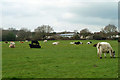
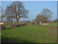
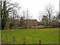
Cattle, Moorlane Farm
The field abuts the Westfield district of Woking.
Image: © Robin Webster
Taken: 18 Mar 2012
0.04 miles
2
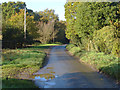
Moor Lane, Westfield
The narrow lane that runs from New Lane to Little Moorlane Farm.
Image: © Alan Hunt
Taken: 5 Nov 2012
0.12 miles
3
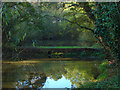
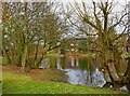
Pond, Westfield Common
The pond off Moor Lane on the edge of Westfield Common.
Image: © Alan Hunt
Taken: 5 Nov 2012
0.15 miles
4
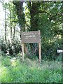
Moor Lane Pond Sign
Moor Lane Pond is a feature of Westfield Common, registered Common Land CL121.
Image: © Westfield Common Residents' Association
Taken: 30 Jul 2011
0.17 miles
5
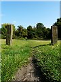
Right of Way across Westfield Common
View of Westfield Common from Moor Lane looking north across a well worn track.
Image: © Westfield Common Residents' Association
Taken: 30 Jul 2011
0.17 miles
6
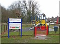
Westfield Common Play Area, near Balfour Avenue
On the edge of the common is this play area, suitable for children up to 12 years old.
Image
Image: © P L Chadwick
Taken: 12 Mar 2010
0.18 miles
7
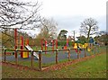
Westfield Common Play Area, near Balfour Avenue
On a cold wet March day the play area, not surprisingly, was completely deserted.
Image
Image: © P L Chadwick
Taken: 12 Mar 2010
0.18 miles
8
Moorlane Farm
Looking north from where the path passes through the farmyard itself.
Image: © Alan Hunt
Taken: 15 Mar 2012
0.18 miles
9
Pond on Westfield Common
The pond is near The Cricketers pub.
Image
Image: © P L Chadwick
Taken: 12 Mar 2010
0.20 miles
10
Pond on Westfield Common
Due to the heavy rainfall of the winter, the pond seems to have extended its area.
Image
Image: © P L Chadwick
Taken: 12 Mar 2010
0.20 miles