IMAGES TAKEN NEAR TO
Riverside Gardens, WOKING, GU22 9LJ
Introduction
This page details the photographs taken nearby to Riverside Gardens, GU22 9LJ by members of the Geograph project.
The Geograph project started in 2005 with the aim of publishing, organising and preserving representative images for every square kilometre of Great Britain, Ireland and the Isle of Man.

There are currently over 7.5m images from over14,400 individuals and you can help contribute to the project by visiting https://www.geograph.org.uk
Image Map
Images are licensed for reuse under creativecommons.org/licenses/by-sa/2.0
Notes
- Clicking on the map will re-center to the selected point.
- The higher the marker number, the further away the image location is from the centre of the postcode.
Image Listing (159 Images Found)
Images are licensed for reuse under creativecommons.org/licenses/by-sa/2.0
Image
Details
Distance
1
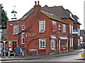
Brasserie Rhone (1), London House, 134 High Street, Old Woking
The building is believed to date from the 17th century, and was timber-framed, but it has been much altered and added to, over the centuries. For a very long period there was a draper's shop here, with a succession of owners. Later it became Old Woking Post Office. After that closed, the building became a French restaurant, which is its present use.
Image
Image: © L S Wilson
Taken: 12 Mar 2010
0.02 miles
2
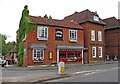
Brasserie Rhone (2), London House, 134 High Street, Old Woking
Comparing this photo to the one taken exactly five months earlier, it is astonishing how, in that period, the ivy has rapidly spread to take over most of the end wall, and part of the roof and chimney.
The restaurant in March 2010:- Image
Image: © P L Chadwick
Taken: 12 Aug 2010
0.02 miles
3
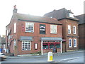
London House
Old brick house on Old Woking High Street, now a restaurant.
Image: © Colin Smith
Taken: 1 Mar 2009
0.02 miles
7
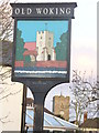
Two for the Price of One
Old Woking church tower on the village sign and in real life.
Image: © Colin Smith
Taken: 1 Mar 2009
0.04 miles
8

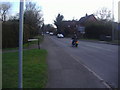
Broadmead Bridge
The Broadmead Bridge carries the A247 road over the original channel of the River Wey. This bridge was built in 1925 and was refurbished in 2004. Its predecessor was a primitive wooden affair, built in 1825. In 1873 a steam engine and threshing machine fell through the side of it and three men were killed. The old river channel marks the boundary between the Borough of Guildford (this side) and the Borough of Woking. Looking N towards Old Woking.
Image: © Ron Strutt
Taken: 2 Oct 2005
0.04 miles
9
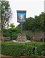
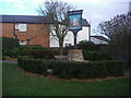
A sign and two seats, Old Woking
By the roundabout at the junction of High Street, and Broadmead Road, this sign has been placed. Around the sign is a small public garden, with seats.
Image: © P L Chadwick
Taken: 12 Aug 2010
0.04 miles
10
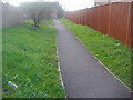
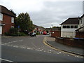
Footpath off Townsend Lane, Old Woking
Image: © David Howard
Taken: 6 Mar 2011
0.05 miles