IMAGES TAKEN NEAR TO
Inwood Close, WOKING, GU22 9FR
Introduction
This page details the photographs taken nearby to Inwood Close, GU22 9FR by members of the Geograph project.
The Geograph project started in 2005 with the aim of publishing, organising and preserving representative images for every square kilometre of Great Britain, Ireland and the Isle of Man.

There are currently over 7.5m images from over14,400 individuals and you can help contribute to the project by visiting https://www.geograph.org.uk
Image Map
Images are licensed for reuse under creativecommons.org/licenses/by-sa/2.0
Notes
- Clicking on the map will re-center to the selected point.
- The higher the marker number, the further away the image location is from the centre of the postcode.
Image Listing (20 Images Found)
Images are licensed for reuse under creativecommons.org/licenses/by-sa/2.0
Image
Details
Distance
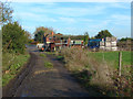
1
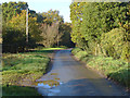
Moor Lane, Westfield
The narrow lane that runs from New Lane to Little Moorlane Farm.
Image: © Alan Hunt
Taken: 5 Nov 2012
0.03 miles
2
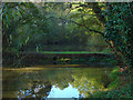
Pond, Westfield Common
The pond off Moor Lane on the edge of Westfield Common.
Image: © Alan Hunt
Taken: 5 Nov 2012
0.05 miles
3
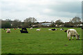
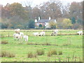
Cattle, Moorlane Farm
The field abuts the Westfield district of Woking.
Image: © Robin Webster
Taken: 18 Mar 2012
0.09 miles
4
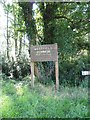
Moor Lane Pond Sign
Moor Lane Pond is a feature of Westfield Common, registered Common Land CL121.
Image: © Westfield Common Residents' Association
Taken: 30 Jul 2011
0.09 miles
5
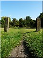
Right of Way across Westfield Common
View of Westfield Common from Moor Lane looking north across a well worn track.
Image: © Westfield Common Residents' Association
Taken: 30 Jul 2011
0.15 miles
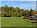
6
Westfield Common
Large flat, grassy area on the Wey flood plain which is used here for cattle and dairy farming.
Image: © Colin Smith
Taken: 14 Nov 2008
0.15 miles
7
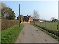
Moor Lane
The short spur road off Moor Lane that runs to the nursery
Image: © Alan Hunt
Taken: 15 Mar 2012
0.16 miles
8
Moor Lane
Looking across Moor Lane with the footpath to The Orchard beside the house on the far side.
Image: © Alan Hunt
Taken: 5 Nov 2012
0.17 miles
9
Farm track, Lower Westfield
The northern end of the footpath across the fields from Robin Hood Lane to Moor Lane with Bramble Hill Cottage in the background.
Image: © Alan Hunt
Taken: 5 Nov 2012
0.18 miles
10
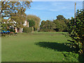
Westfield Common
Looking north across the triangle of common land in front of Rose Bank Cottages.
Image: © Alan Hunt
Taken: 5 Nov 2012
0.18 miles