IMAGES TAKEN NEAR TO
Bassett Road, WOKING, GU22 8ET
Introduction
This page details the photographs taken nearby to Bassett Road, GU22 8ET by members of the Geograph project.
The Geograph project started in 2005 with the aim of publishing, organising and preserving representative images for every square kilometre of Great Britain, Ireland and the Isle of Man.

There are currently over 7.5m images from over14,400 individuals and you can help contribute to the project by visiting https://www.geograph.org.uk
Image Map
Images are licensed for reuse under creativecommons.org/licenses/by-sa/2.0
Notes
- Clicking on the map will re-center to the selected point.
- The higher the marker number, the further away the image location is from the centre of the postcode.
Image Listing (7 Images Found)
Images are licensed for reuse under creativecommons.org/licenses/by-sa/2.0
Image
Details
Distance
1
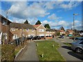
Maybury Estate - Beaufort Road
Post war estate outside Woking.
Image: © James Emmans
Taken: 11 Feb 2018
0.14 miles
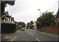
2
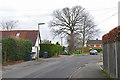
Beaufort Road, Woking
Beaufort Road in the Maybury Estate.
Image: © Alan Hunt
Taken: 26 Jan 2016
0.18 miles
3
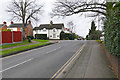
East Hill, Woking
The northwest end of East Hill in Maybury looking towards the junction with Sandy Lane. Over the brow of the hill the road is named College Road.
Image: © Alan Hunt
Taken: 26 Jan 2016
0.19 miles
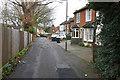
4
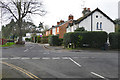
Sandy Lane, Woking
Looking across East Hill from Beaufort Road towards Sandy Lane in the Maybury area of Woking.
Image: © Alan Hunt
Taken: 26 Jan 2016
0.20 miles
5
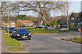
Princess Road, Woking
The green on Princess Road in the Mabury Estate.
Image: © Alan Hunt
Taken: 17 Mar 2016
0.20 miles
7
Frailey Hill, Woking
Frailey Hill in the Maybury Estate.
Image: © Alan Hunt
Taken: 26 Jan 2016
0.23 miles