IMAGES TAKEN NEAR TO
Sandy Lane, WOKING, GU22 8BW
Introduction
This page details the photographs taken nearby to Sandy Lane, GU22 8BW by members of the Geograph project.
The Geograph project started in 2005 with the aim of publishing, organising and preserving representative images for every square kilometre of Great Britain, Ireland and the Isle of Man.

There are currently over 7.5m images from over14,400 individuals and you can help contribute to the project by visiting https://www.geograph.org.uk
Image Map
Images are licensed for reuse under creativecommons.org/licenses/by-sa/2.0
Notes
- Clicking on the map will re-center to the selected point.
- The higher the marker number, the further away the image location is from the centre of the postcode.
Image Listing (20 Images Found)
Images are licensed for reuse under creativecommons.org/licenses/by-sa/2.0
Image
Details
Distance
1
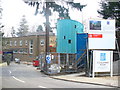
St Columba's House
Retreat and conference centre on Maybury Hill, Woking. The green section is under construction (2009).
http://www.stcolumbashouse.org.uk/
Image: © Colin Smith
Taken: 1 Mar 2009
0.07 miles
2
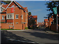
The Pinnacles, Maybury
The newly built Pinnacles development based on Convent Road.
Image: © Alan Hunt
Taken: 1 Oct 2011
0.07 miles
3
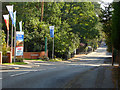
Maybury Hill, Woking
A view along Maybury Hill with the recently built Pinnacles development on the right.
Image: © Alan Hunt
Taken: 1 Oct 2011
0.09 miles
4
Maybury Rough, apartments beside Maybury Hill
Image: © Roger Templeman
Taken: 17 Feb 2015
0.12 miles
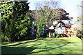
5
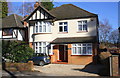
'Croftdale', Maybury Hill
There is an OS benchmark Image on the right hand side of the house near its front corner
Image: © Roger Templeman
Taken: 17 Feb 2015
0.12 miles
6
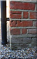
Benchmark on 'Croftdale'
Ordnance Survey cut mark benchmark described on the Bench Mark Database at http://www.bench-marks.org.uk/bm64362
Image: © Roger Templeman
Taken: 17 Feb 2015
0.12 miles
7
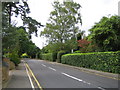
Maybury: Shaftesbury Road
Typical residential road in the Maybury area of Woking.
Image: © Nigel Cox
Taken: 20 Sep 2006
0.14 miles
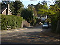
8
Sandy Lane, Woking
Looking across East Hill from Beaufort Road towards Sandy Lane in the Maybury area of Woking.
Image: © Alan Hunt
Taken: 26 Jan 2016
0.15 miles
9
Dorset Drive, Maybury
A view along Dorset Drive from Shaftesbury Road.
Image: © Alan Hunt
Taken: 1 Oct 2011
0.15 miles
10
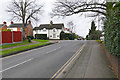
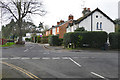
East Hill, Woking
The northwest end of East Hill in Maybury looking towards the junction with Sandy Lane. Over the brow of the hill the road is named College Road.
Image: © Alan Hunt
Taken: 26 Jan 2016
0.17 miles