IMAGES TAKEN NEAR TO
Cardigan Close, WOKING, GU21 8YP
Introduction
This page details the photographs taken nearby to Cardigan Close, GU21 8YP by members of the Geograph project.
The Geograph project started in 2005 with the aim of publishing, organising and preserving representative images for every square kilometre of Great Britain, Ireland and the Isle of Man.

There are currently over 7.5m images from over14,400 individuals and you can help contribute to the project by visiting https://www.geograph.org.uk
Image Map
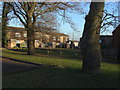
Images are licensed for reuse under creativecommons.org/licenses/by-sa/2.0
Notes
- Clicking on the map will re-center to the selected point.
- The higher the marker number, the further away the image location is from the centre of the postcode.
Image Listing (43 Images Found)
Images are licensed for reuse under creativecommons.org/licenses/by-sa/2.0
Image
Details
Distance
1
Inkerman Estate, Knaphill
Late 1970s housing on the site of the former Inkerman Barracks.
Image: © Alan Hunt
Taken: 14 Jan 2012
0.01 miles
2
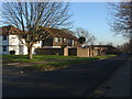
Inkerman Way, Knaphill
A view down Inkerman Way which runs from Raglan Road alongside the housing developments built in the late 1970s on the site of the Inkerman Barracks. Many of the roads names have a Crimean War connection. The playing fields of the Winston Churchill school are to the right.
Image: © Alan Hunt
Taken: 14 Jan 2012
0.04 miles
3
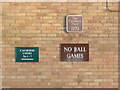
The writing on the wall
A collection of signs on the end of the block of housing near the junction of Iveagh Road with Bingham Drive.
Image: © Alan Hunt
Taken: 14 Jan 2012
0.06 miles
4
Iveagh Road, Knaphill
Guinness Trust housing with the junction of Iveagh Road from Bingham Drive.
Image: © Alan Hunt
Taken: 14 Jan 2012
0.06 miles
5
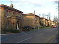
Raglan Road, Knaphill
The Victorian army houses, once part of the Inkerman Barracks, now converted to flats.
Image: © Alan Hunt
Taken: 7 Jan 2012
0.13 miles
6
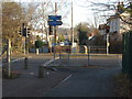
Barrack Path
Barrack Path runs alongside the lower stretch of Inkerman Way and crosses Amstel Way (the St Johns bypass) on it way to the centre of St Johns.
Image: © Alan Hunt
Taken: 14 Jan 2012
0.15 miles
7
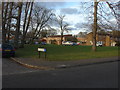
The green, Raglan Road
The small green on Raglan Road. Alma Close, built on the site of the Army storage depot in the early 1990s is in the background.
Image: © Alan Hunt
Taken: 7 Jan 2012
0.15 miles
8

The entrance to Winston Churchill School Sports Centre
Hermitage Road, Knaphill
Image: © David Howard
Taken: 9 Oct 2016
0.16 miles
9
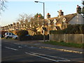
Wellington Terrace, Knaphill
The southern end of the terrace of Victorian cottages, once part of the Inkerman Barracks from Victoria Road.
Image: © Alan Hunt
Taken: 14 Jan 2012
0.17 miles
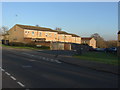
10
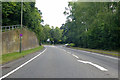
A324 Amstel Way, Woking
Towards, rather indirectly, the town centre.
Image: © Robin Webster
Taken: 2 Aug 2020
0.17 miles